Neighbors appeal 80-unit subdivision - locals concerned with density & traffic safety
Points of clarification
The original headline for this story “City approved 80-unit subdivision without hearing or sidewalks - Locals concerned with density & traffic safety, appeal to city council” was not stated clearly enough.
First Issue: “without hearing”
City planners did approve the subdivision in March with no hearing. However, neighbors hired an attorney and appealed that decision. The City of the Dalles Planning Commission held a hearing and took public comment. The Commission then denied the community members appeal and approved the subdivision at its July 16 meeting.
Commissioners Brent Bybee, Cody Cornett and Bruce Lavier voted in favor of the resolution that denied the appeal and approved the development. Commissioner Jeff Stiles opposed it. Alan Easling and Philip Mascher abstained from the vote. Mark Poppoff was absent.
Second Issue: “without sidewalks”
Legacy Development plans to install sidewalks within its proposed development, as is required by planning codes. Rather, neighbors are concerned with the lack of sidewalks on 10th and 12th streets leading west to Thompson Street. They believe it will create a higher safety risk for additional children and adults who will eventually live in the new development. Legacy Development is not required to install those sidewalks.
We apologize for any miscommunication due to the headline - Tom Peterson
By Tom Peterson
While developers feel that an 80-unit subdivision on 6.92 acres in East The Dalles will help the community meet the demand for housing, neighbors and community members believe it will cause extensive safety issues because of a lack of surrounding infrastructure.
In question is the Legacy Development’s subdivision, The Grove, at 2845 E. 12th Street in Thompson’s edition.
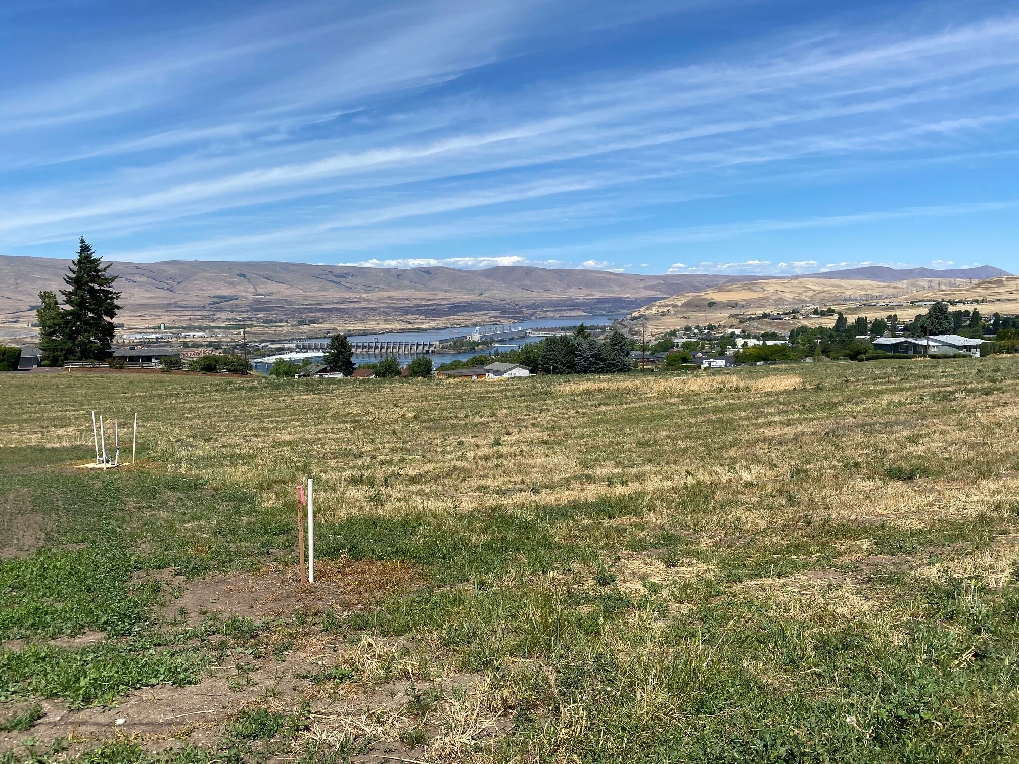
Legacy Development is intending on putting 80 housing units on this 6.92 acres of property in East The Dalles.
Thompson’s edition was originally platted with one acre lots for single family homes in1889. In 1994 the zoning was changed to multi-family high density. The plan was adopted on may 11, 1998.
Neighbor Randy Hager contends the zoning change required the city to build out the infrastructure that would support future development of multi-family residences.
Spring forward 22 years. Much of the infrastructure remains unchanged, yet city planners have approved the multi- family development. Neighbors are asking the city to explain how they are going to provide and pay for the infrastructure to support such a drastic change in use.
“They are obligated to provide services such as streets, sewer, storm drain, electricity, phone, cable - and now who is going to provide those services. What’s the bill, and what’s the city’s explanation for how they are going to pay for it,” Hagar said.
Area homeowners are suggesting a smaller amount of homes would lighten the obligation to the city and still provide up to 28 single-family residences for this “remarkably beautiful” development site.
The Dalles Planning Commission denied the community members appeal and approved the subdivision at its July 16 meeting.
Commissioners Brent Bybee, Cody Cornett and Bruce Lavier voted in favor of the resolution that denied the appeal and approved the development. Commissioner Jeff Stiles opposed it. Alan Easling and Philip Mascher abstained from the vote. Mark Poppoff was absent.
Denise Lynne Dietrich-Bokum and Robert Clayton Bokum, Gary Gingrich and Terri Jo Jester Gingrich, and Damon Rolla Hulit and Roberta Kay Wymore Hulit are now appealing that decision to the City council. The hearing is slated for Aug. 24th.
Legacy Development, owned by Cameron Curtis and Dick Smith, both of Hood River, are currently intending on building triplexes, duplexes and single family homes on th 6.92 acres.
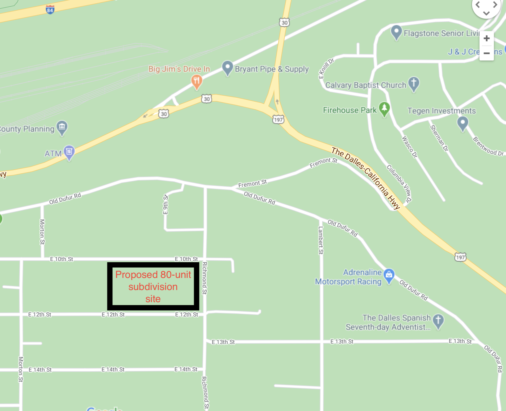
Proposed location for Legacy Development’s high-density subdivision called “The Grove.”
The plan also calls for adding 11 accessory dwellings within the development for a total of 80 housing units and a pocket park for residents. The property was previously utilized for agriculture for more than 100 years. It was most recently sold by John Geiger. It was formerly a cherry orchard, and as late as this summer, was used for growing barley.
In the appeal, attorney Steve Morasch contends that 80-housing units “is wholly incompatible with the neighborhood, creating serious safety concerns and led to inadequate planning in the transportation system plan for high-density development.
The safety of current and future residents and the cost of bringing the neighborhood up to standard sits squarely on the city’s shoulders, Hager contends. Should neighbors be burdened with the cost of infrastructure - especially five years down the road after a decision to approve the housing development is long past, he asked.
Infrastructure is an expensive proposition. Asphalt, curbs, sidewalks and proper storm drainage would cost several million dollars for 10th and 12th streets alone.
And no one wants the bill.
State regulations require all infrastructure to be in place and ready to serve development prior to municipal approval of development, Hager said. “That’s the law,” Hager said.
Columbia Community Connection sought an interview with Community Development Department Director Steven Harris to get additional information. He deferred to the planning documents from past hearings and made no comment.
”I and other City staff, have been advised by the City Attorney not to consent to an interview with the media until after the City Council has made a determination re the appeal of the Planning Commission’s action on the Legacy Development application,” he wrote in an email.
STREETS AND SIDEWALKS
Twelfth and 10th streets, which would provide access for future residents at the subdivision, lack curbs and sidewalks until they reach Thompson Street. That’s a half mile on each street.
Neighbors fear that children who would live in the proposed housing development could be injured while bicycling or walking the steep streets.
“The key issue is the danger of the streets up here, said Loyal Quackenbush who lives down the street from the proposed development.
There are only small portions of existing sidewalks on 12th and 10th streets and no designated bike lanes in the neighborhood presently.
“You can not put that many people on the streets.” Tenth and 12th streets and Dufur Road are incompatible for children either walking or riding bikes, he said. Both Tenth and 12th are on steep grades to the west and are about a half mile before hitting contiguous sidewalks at Thompson Street, which provide a safe space for pedestrians.
Neighbors have espoused fears that intersections that would service the new housing development are substandard and would also be further diminished with additional traffic from the new subdivision.
CASE IN POINT
For example, neighbors point out that new residents at the subdivision would use the intersection at Freemont Street and Highway 197 to access I-84 to travel to grocery stores, for example.
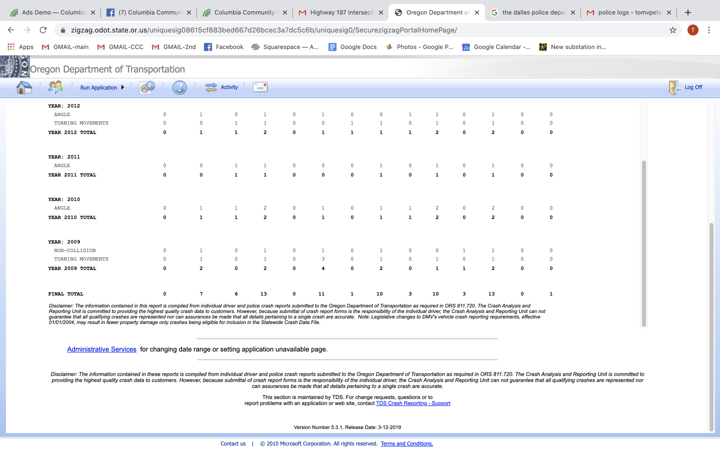
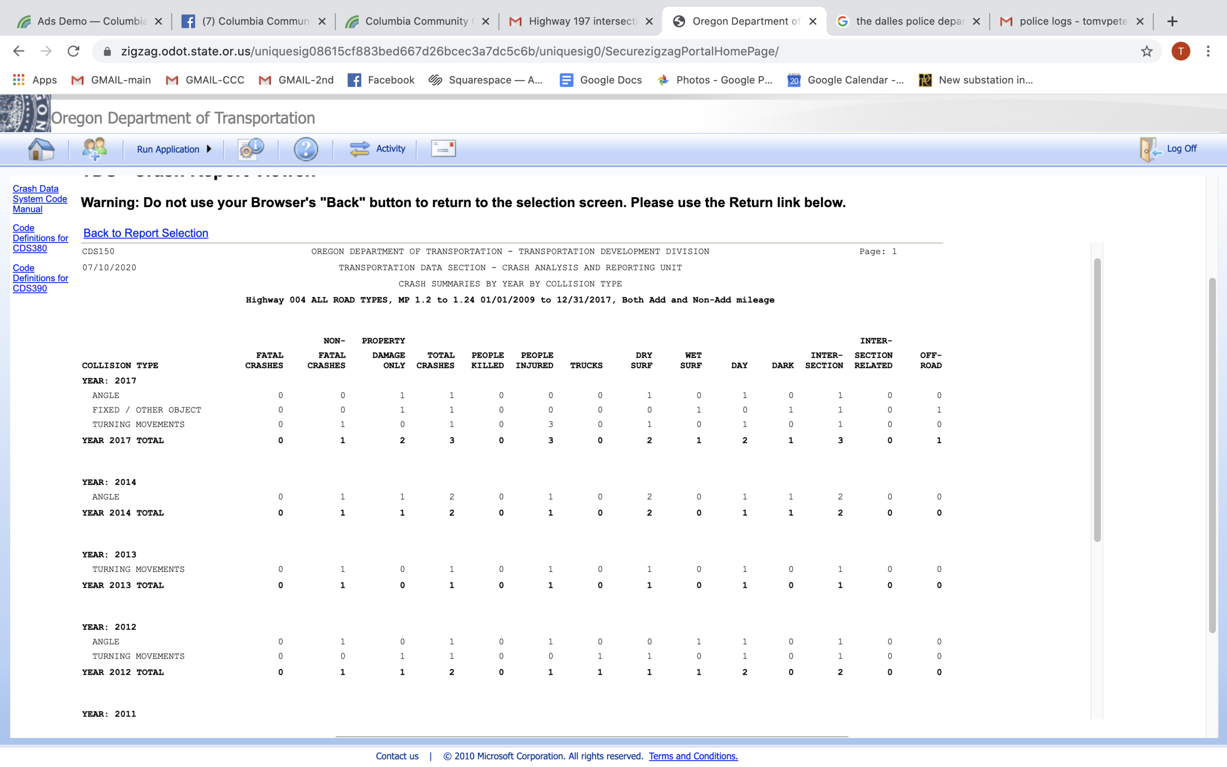
To that point, the Oregon Department of Transportation reported that the intersection, including 200 feet of pavement north and south, has had 13 crashes between 2009 and 2017, according to the latest crash data reporting available. Eleven resulted in injury.
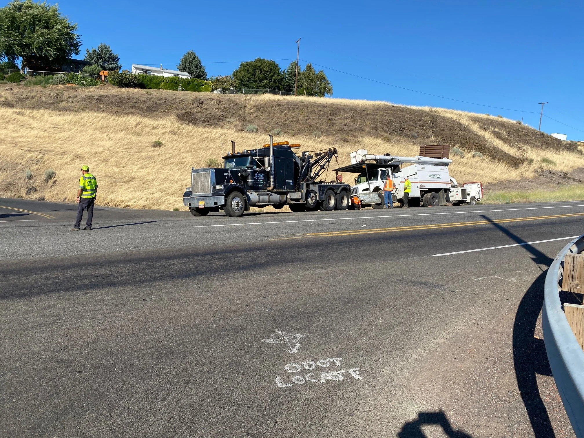
And on July 8th at 4:54 p.m., another person went to the hospital when a Chevy Malibu made a southbound turn onto Highway 197 from Freemont Street and struck a Toyota, pushing it into an ODOT Trees Inc truck that was northbound. “The driver of the Toyota had significant injuries and was transported to MCMC by ambulance,” said The Dalles Police Capt. James Carrico.
Carrico said drivers headed south on 197 are getting up to speed in that portion of the road and the visibility “makes it tough for that intersection.”
He was well aware of past crashes at the intersection, and it gets even more dangerous in winter when long shadows keep it icier longer, he said.
Past estimates to overhaul the intersection of Highway 197 and Freemont were around $2 million. “That would meet some of the requirements of this development and other future subdivisions,” Hager said.
Tow truck drivers hook up to an Oregon Department of Transportation Trees Inc. vehicle after three vehicles collided at Freemont and Highway 197 on July 8th. Neighbors contend that a high-density subdivision will add traffic to “this already dangerous” intersection.
Oregon Department of Transportation crash data on Highway 197 and Freemont.
Oregon Department of Transportation crash data on Highway 197 and Freemont, Page 2.
TRAFFIC STUDY
Community members are emphatic that new construction will create safety risk as parents and children from the proposed development would be using streets in the area in years to come. If every housing unit brought an additional two cars to the neighborhood, there would be 160 more vehicles on the road in the neighborhood.
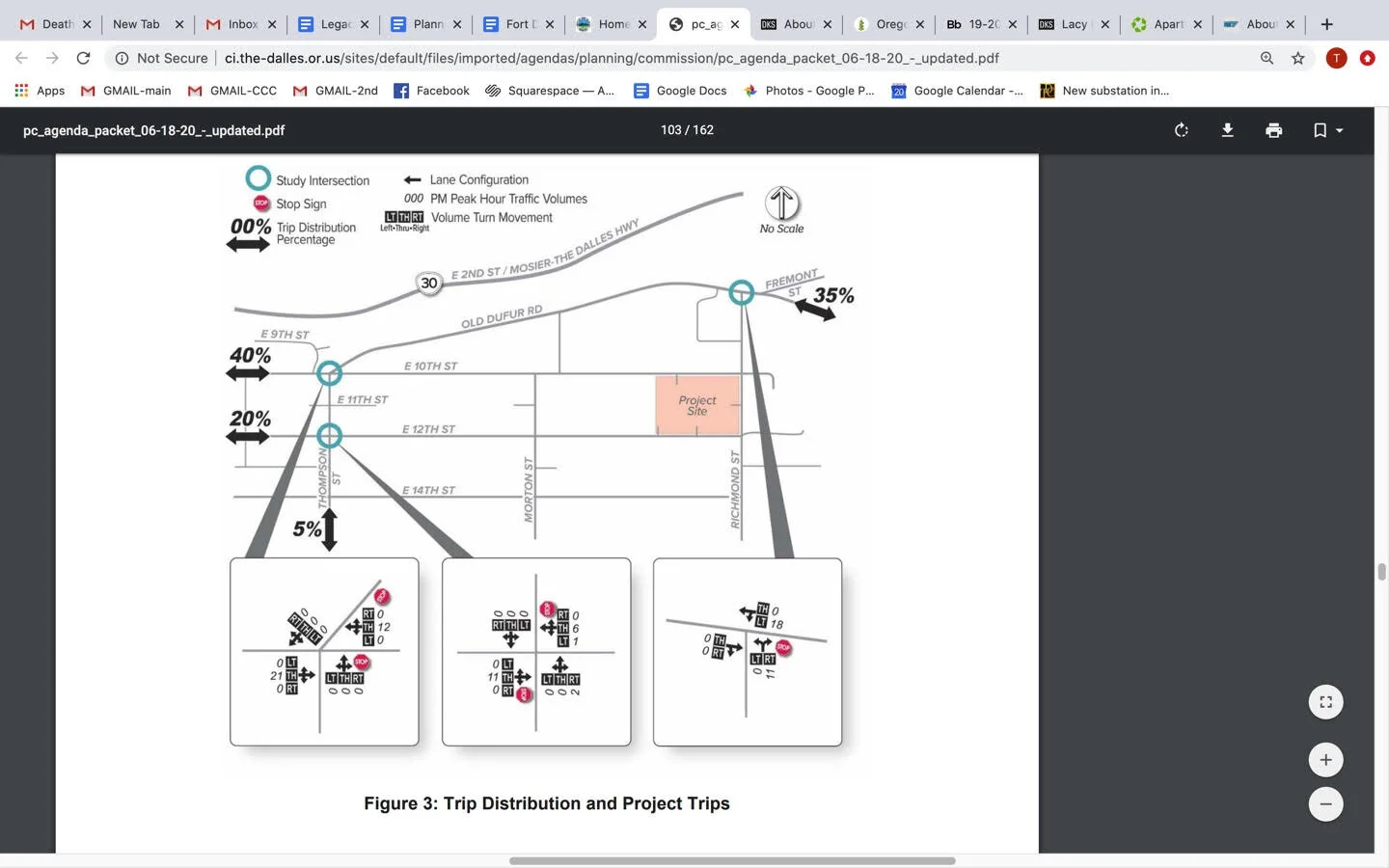
Legacy Development hired DKS Associates of Salem, a transportation planning firm, to do a traffic study to assess the impact on local streets. DKS gathered data at several intersections - the three-way - 10th Street , Thompson Street and Old Dufur Road. It also studied the intersections of 12th and Thompson streets and Old Dufur Road and Richmond Street. DKS took traffic data at the intersections on Jan 9., for one hour between 4 and 6 p.m. They then used the Institute of Transportation Engineers Trip Generation Manual to forecast future traffic - a requirement of the planning department.
The study shows 82 traffic trips at that “peak” hour.
Here are the three intersections studied by DKS Associates of Salem on behalf of Legacy Development. The traffic study looked at intersections for one hour on Jan. 9th.
Neighbors have protested that the traffic study was insufficient to show the true nature of traffic as it was only done for a single hour on a single day.
DKS’s Lacy Brown told the planning commission that all of the intersections studied would continue to operate at favorable city standards, even with 160 percent increase of the data they attained during the study.
The attorney for the neighbors pointed out that the intersection trips of Freemont and Highway 197 were not included in the study, stating it was flawed.
Brown said that the highway intersection was listed as exceeding Oregon Department of Transportations critical crash rate. But she contested the designation as an Urban Intersection. In her opinion, she said it is a rural intersection, which would downgrade that crash rate.
“However, the City did require that the Fremont St. segment of the intersection be evaluated to determine the stacking and queue lengths as a result of the additional traffic generated by the development. Overall, the change would result in an intersection queue increase of 10’ between current conditions (2020) and future 2028 conditions,” according to the planning report.
Neighbors contend that anyone living in the new housing development would assuredly use the Freemont and 197 intersection to access Interstate 84 to drive to Fred Meyer, for example.
Neighbor Gary Gingrich was most concerned with the intersection of Thompson, 10th streets and Dufur Road, noting the housing development would compound the traffic problem.
“With multiple intersections underdeveloped in the city, is it ok to put high density homes upstream from these? Why should we compound the problem, or did your study suggest that,” he asked Brown during the meeting.
“I was not implying to not look at nearby intersections,” she responded at the meeting. “Just because there is an issue does not require us to look at it... there might be a handful of people that travel to various intersections in the city - we have to actually focus our analysis.”
GOING DEEPER
This most recent development for neighbors and residential property owners goes deeper than this one subdivision. Neighbors say it is the tip of the iceberg as more property will be purchased in the area and developed with high density housing, which allows for seven to more than 11 units per acre.
This recent argument speaks to the history of paying for infrastructure development in The Dalles during the past several decades.
For years, the city would agree to partitions of residential property or permit development if owners in exchange would agree to pay assessments for infrastructure such as sidewalks, curbs and streets which could cost thousands.
Some assessments for curbs and sidewalks can be in the hundreds of thousands of dollars as costs were calculated based on linear property lines abutting streets.
For a period of time, many property owners did not partition or build because of the cost of those assessments.
Former The Dalles Mayor Steve Lawrence said that struggle came to a head in the early 2010s. And House Bill 3479 was passed in 2013 to stop the city from making those assessments.
HERE’S THE BILL
“Enrolled House Bill 3479 Sponsored by Representative HUFFMAN CHAPTER
AN ACT Relating to city fees; and declaring an emergency. Be It Enacted by the People of the State of Oregon: SECTION 1. When the owner of property that is located in a city in Wasco County with a population greater than 5,000 and that is zoned for residential use files an application for a partition, as defined in ORS 92.010, or a subsequent application for a permit in furtherance of the partition, for the property, the city may not, as a condition of approval of the application: (1) Assess: (a) A charge in lieu of forming a local improvement district; or (b) A prepayment against an assessment for a future local improvement district; or (2) Require the owner of the property to enter into a non remonstrance agreement with respect to the future formation of a local improvement district. SECTION 2. Section 1 of this 2013 Act is repealed on July 1, 2023. SECTION 3. This 2013 Act being necessary for the immediate preservation of the public peace, health and safety, an emergency is declared to exist, and this 2013 Act takes effect on its passage.”
That House Bill is set to expire in 2023.
That worries Lawrence who said current and future residential property owners could possibly get stuck footing the bill for infrastructure in the not-to-distant future. Street assessments exceeded $385 a lineal foot 10 years ago. “There is full indication that the cost of full infrastructure development is in the hands of the city, not homeowners,” Lawrence said.
Former The Dalles Mayor said city planners missed a critical step in engaging the community in a discussion locating a high-density subdivision in East The Dalles. He also worries that the costs for infrastructure will be put on residents owning existing homes.
COMMUNITY INPUT
Public testimony was allowed during the preliminary plat approval process. Once a developer gains preliminary approval, the developer submits the engineered drawings, and it is up to the planning department to ensure that the project complies with all requirements.
Neighbors disagree with that process.
Planning Commission Chair Brent Bybee pointed out that final approvals also required the inspection and signature of the planning commission as well as Wasco County Planning Department.
During the planning meeting on June 18, Legacy Development president Cameron Curtis asked for clarification on the project. “Is it common at this point to provide fully engineered plans, or is it normal to get preliminary plans and then get conditions of approval?”
Planner Joshua Chandler responded, “At this stage of development, we require preliminary plans. The reasons for this and not engineered plans is so that the developer does not accrue undue development costs… and then staff deny that application. That puts a heavy feat on the applicant.”
“Did we provide everything required for the city?” asked Curtis of city staff.
“We felt that you did, and those were the findings in the staff report,” Chandler responded.
Going Deeper
Lawrence said the new development is not what was envisioned when he went through two visioning plans with the city, one in 2002 and a second in 2011.
Lawrence said 20-year plans behind zoning in the 90’s were built on projections that The Dalles was looking at nearly doubling in population to some 25,000 within 20 years.
A rate that never came to fruition. The current estimate for The Dalles is 14,820, according to Portland State University.
In total, The Dalles needs to build 1300 housing units during the next 20 years, which could easily be achieved by building homes with infill rather than high density residential housing, Lawrence said.The idea behind The Dalles Comprehensive Plan was to build outward so that infrastructure such as streets and sidewalks would already be in place.
Lawrence said revitalization of the second floor of downtown buildings was also to provide housing for increased population, and that was a key part of that vision.
He referred to the current process as a “bastardization” of the visioning plan as it sets some 80 housing units far from the interior of the city on streets that can’t handle additional traffic.
“This project will be an island, ” he said.
“The overall comprehensive philosophy is to do what the citizens want. They (planners) really need to be out in the community holding neighborhood meetings and involving people with a lot of development. An inclusive approach - that’s what was missing here.”
Attorney for the neighbors, Steve Moscher makes the same comment in the appeal, pointing to statewide land use planning goals that require citizen involvement “in all phases of the planning process.”
He said the current planning departments administrative decision cuts short the public process “by deferring review of numerous mandatory code requirements into the second stage of the review process” for Legacy Development’s subdivision, “thus depriving the public of the opportunity to meaningfully review and comment on the proposal.”
WHAT’S BEST FOR OUR COMMUNITY?
Legacy Development is proposing the 80-unit development to address a housing shortage in The Dalles. Rents are up to around $1,600 for a two bedroom, one bath home in The Dalles. Realtors and property managers make no bones about the need for additional housing as it is far outpacing the housing stock. Legacy Development’s President Cameron Curtis told neighbors Legacy was doing a favor for The Dalles by providing working people the homes they needed.
While city planners say Legacy is meeting the conditions and standards for the proposed development. Neighbors contend the spirit of the law which generally provides for safe streets and a robust infrastructure to accompany new development is not being met.

