
Boulder Fire coming on as Tunnel 5 fire hits 65% containment
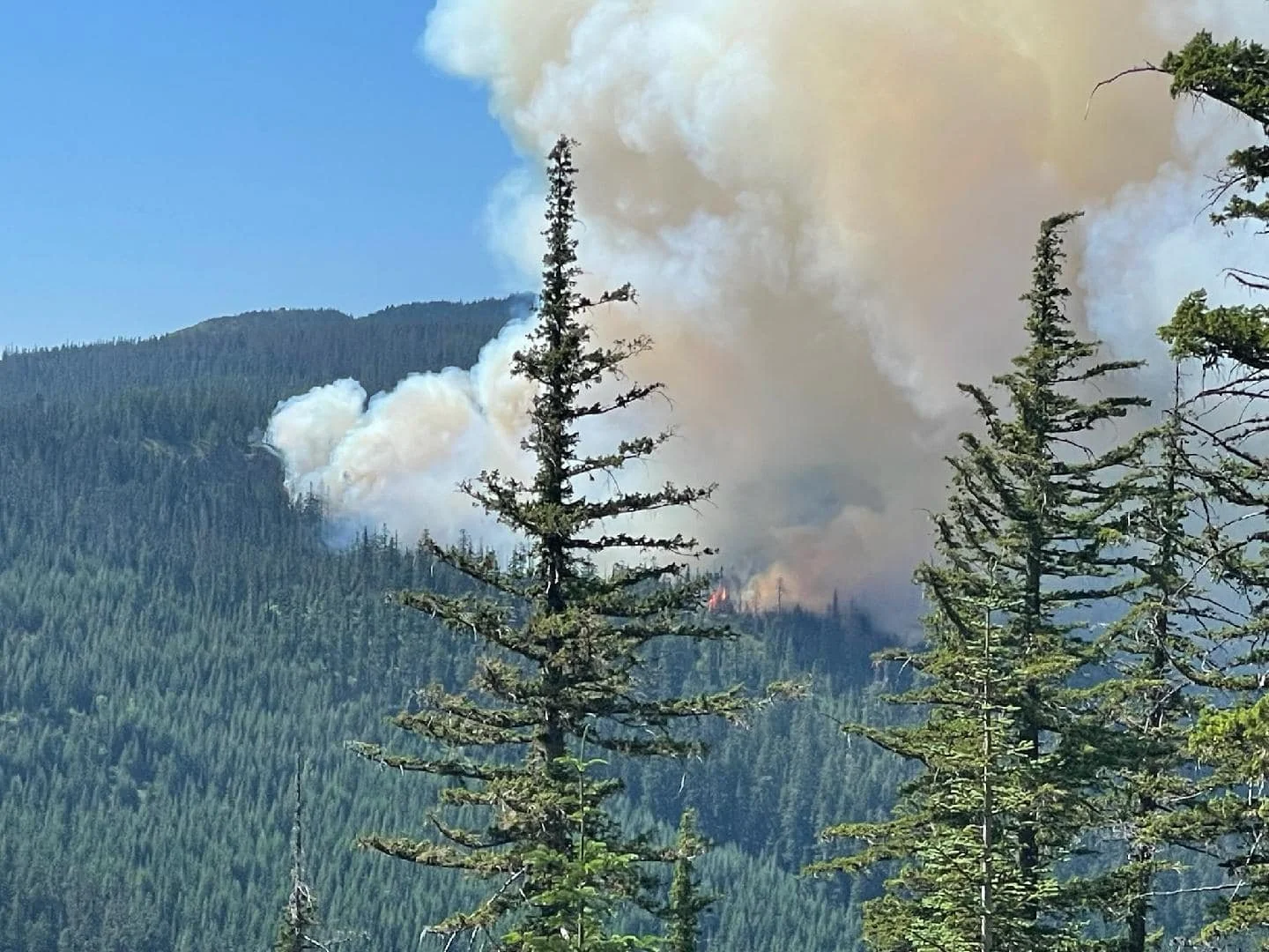
The Bolder Fire burning just 13 air miles west of Wamic is burning in tall timber in the Mt. Hood National Forest. Photo from Wasco County Sheriff’s Facebook page.
By Tom Peterson
The Dalles, July 9, 2023 - Firefighters are being pulled in multiple directions as multiple fires have broken out in Oregon, including the uncontained 60-acre Boulder Fire just 13 air miles west of Wamic in tall timber in the Mt. Hood National Forest.
In Oregon, there are a total of 15 active fires with 2,108 acres burned, according to the state’s 2023 Wildfire Situation Dashboard.
This comes just as it appears fire managers are getting an upper hand on the Tunnel 5 Fire near Underwood and White Salmon, Wash., along Highway 14 with a report of 65 percent containment this morning, July 9. Managers are preparing to reduce personnel on that fire during the next two shifts.
At the same time, The Alder Creek Fire east of us near Spray, Ore., and the John Day River has consumed more than 2,000 acres in Wheeler County.
And just last night a fire was detected near Pine Grove southwest of Maupin near Highway 216. It is called the Kelly Springs Fire thus far, and there was no official number on the acres involved there.
Fire location map. Click to enlarge.
BOULDER FIRE
Update via the US Forrest Service:
Sandy, OR—July 9, 2023. Firefighters are engaged in suppressing the Boulder Fire, which started on July 8th southeast of Mt. Hood on the Barlow Ranger District near Boulder Lake Trailhead. As of this morning, the fire is estimated to be over 60 acres.
The fire is burning in a heavily forested area on steep slopes. Four engines, four hotshot crews and two heavy helicopters are actively working on the fire, with additional resources en route.
Boulder Lake Campground, Little Boulder Lake, Bonney Meadow Campground, Badger Lake Campground, Camp Windy, and Post Camp Campground remain under a Level 3 – Go Now evacuation. Forest Roads 4480, 4481, and 4890 are also closed. An area closure is in the process of being implemented for public safety. Visitors are asked to avoid the area as conditions can change quickly.
Winds are forecast in the area to be 5-15mph in the morning, increasing in the afternoon from 15-20 with gusts up to 35mph, according to an update from Columbia Gorge Wildland and Fire Information.
Smoke impacts are anticipated in the vicinity of the fire, with warm and dry conditions forecast to persist throughout the week. Visit oregonsmoke.blogspot.com or airnow.gov for air quality updates.
The cause of the fire is under investigation.
A Type 2 Incident Management Team will transition to managing the fire tomorrow morning,July 10.
For additional fire information visit us on Facebook at www.facebook.com/mthoodnf/
TUNNEL 5 FIRE
Ground and air crews fighting the blaze have kept the size of the fire to 559 acres and the official report this morning is that the fire is 65 percent contained - meaning firebreaks have been constructed via hand and heavy equipment around approximately two-thirds of the fire. That number stood at just 35% yesterday.
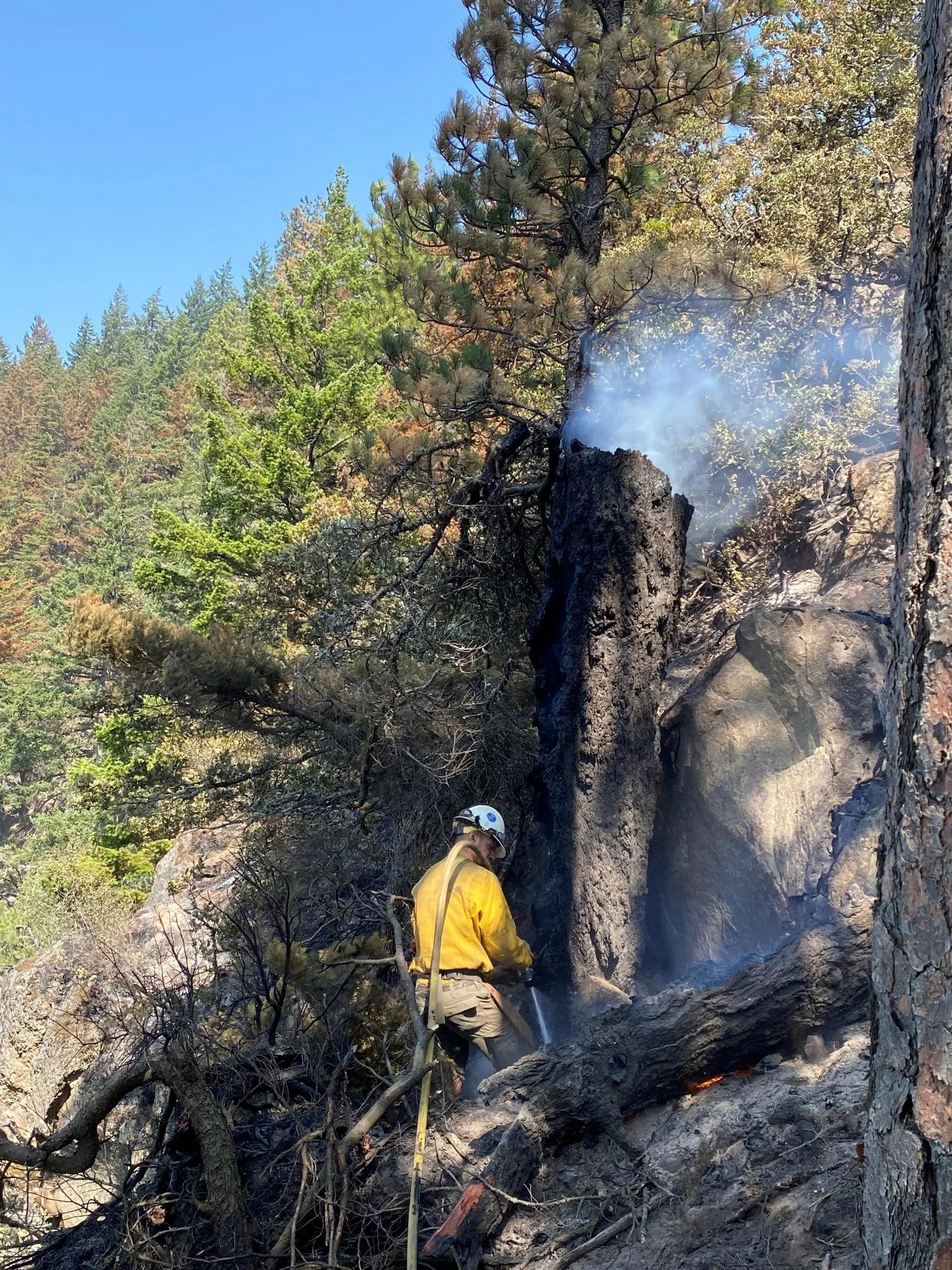
Photo from Columbia Gorge Fires Facebook page
The cause of the fire is still undetermined, and there are no reports of injuries.
“Firefighters continue to patrol and hold control line around the fire,” reported Northwest Incident Management Team 12 this morning. “Crews and equipment will be working along the Cook-Underwood Road in close proximity to the roadway today, July 9. This road is open to local traffic only. Please slow down near working crews and use extreme caution for the safety of firefighters.”
“Temperatures across the fire area dropped yesterday, July 8, as did wind speeds, reducing fire activity inside containment lines. Today, humidity recovery is better in the fire area. (Humidity tecovery relates to the amount of moisture in fine fuels such as grass and sticks - in this instance it has increased, which slows the fire.) Warmer temperatures and erratic winds from nearby storm systems could contribute to increased fire behavior within the perimeter today, July 9.”
“Mop-up and structure protection will be ongoing as NW Team 12 prepares for the demobilization of most firefighting resources over the next two shifts. Remaining fire crews and equipment will be utilized to monitor the fire area for the next several days as warmer temperatures and higher wind speeds return to the area throughout next week and pockets of interior fuels continue to consume.
Safety and Closures
Washington State Route 14 remains closed between mile markers 56-65 due to safety hazards from fire-weakened trees and terrain that has been compromised by fire activity. Crews are actively engaged in clearing these safety hazards to safely reopen the highway. There is a Temporary Flight Restriction over the Tunnel Five Fire area. Wildland fires are a “no-fly zone” for drones. If you fly, WE CAN’T. Smoke and aircraft will be visible within the I-84 corridor.
With the expectation of increased recreational traffic this weekend, we ask drivers and boaters to be extremely cautious on the water and roadways in the fire area, watching for firefighters and apparatus as they continue suppression efforts. Stay clear of areas on the river where aircraft may be dipping or drawing water. Visibility on roadways within the fire area may be impacted by smoke. Please drive slowly and be mindful of crews working in the area.
Evacuations
All Skamania County evacuation levels have been reduced to level 1 (BE READY). Visit Skamania County Sheriff’s Facebook page at https://www.facebook.com/SkamaniaSheriff for more info. The evacuation shelter at Skamania County Fairgrounds has been closed.
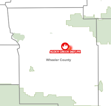
ALDER CREEK FIRE
Additional firefighters and equipment ratcheted up in Wheeler County on Saturday, July 8 to aid in battling the Alder Creek Fire burning near Spray.
The wildland fire burning near the John Day River was last estimated at 2,005 acres.
Red Flag warnings for high temperatures and low humidity along with conditions for lightning are complicating the fight.
The Wheeler County Sheriff’s Department is in contact with residents and landowners for potential evacuation needs, including one home south of the fire and homes on the north side of the John Day River, according to the Central Oregon Daily News.
KELLY SPRINGS FIRE
Satellite heat imaging is also indicating a new fire on Highway 216 near Pine Grove and southwest of Maupin.