
Concerns Mount Over Klickitat County’s Land Subdivision Practices
By Robin Denning
Klickitat County, WA. May 23, 2025 – Land use decisions in Klickitat County, typically the realm of quiet planning meetings, are now at the center of a heated controversy. Recent allegations suggest the county may have allowed land to be divided in ways that skirt Washington’s subdivision laws, potentially creating new building lots outside the normal public process. At stake, critics say, is the integrity of the county’s development rules – rules meant to ensure orderly growth, adequate infrastructure, and fairness for all property owners.
The issue exploded into public view after local resident Steve Wolfram raised concerns on social media and at public forums. Wolfram pointed to specific cases – including a seven-lot split of an old orchard tract near Dallesport and a 26-lot subdivision proposal in the same area – as emblematic of a broader problem. “These aren’t just paperwork quirks,” Wolfram argued in one post. “They go to the bedrock of orderly community development.” His charges have prompted calls for greater transparency and an investigation into whether bureaucratic oversights or deliberate end-runs around the law are to blame.
Controversial Land Splits: Tract 13 and the Maley Subdivision
One focal point is the subdivision of Tract 13 of the North Dalles Fruit and Garden Tracts, a property near Dallesport owned by local developer Greg Wallace. In 2017, a survey was recorded that reportedly carved Tract 13 into seven separate lotsfacebook.com. Neighbors and watchdogs were startled: normally, creating that many new lots would require a formal subdivision plat application, involving public hearings, infrastructure planning, and County approval under state law. Yet in this case, no conventional plat process was apparent – the lots simply appeared on paper after the survey. “It was essentially a subdivision by survey,” Wolfram alleged, arguing that this maneuver circumvented the review that would typically accompany chopping one tract into seven. County planning staff later acknowledged the situation, and questions remain about how the split was allowed to happen without triggering the normal requirements.
A second case drawing scrutiny involves William Maley and a tract of land in Dallesport that he sought to develop. In 2018, Maley applied for approval to subdivide an 8.60-acre parcel into 26 lots – an ambitious plan to create a new neighborhood on a patch of land just north of the Columbia Riverklickitatcounty.gov. What made this proposal contentious was its origin: the parcel was a product of a 2005 boundary line adjustment (BLA #2005-08) combined with portions of an old plat dating back to the mid-20th century (specifically, Lots 1 and 2, Block C of the 1946 Plat of Dallesport). In essence, Maley’s project was built on an “antiquated plat” – a subdivision map drawn up in 1946 – which he now sought to build out in 2018 under modern zoning. County commissioners were asked to approve the 26-lot division in a public meetingklickitatcounty.gov.
For critics, Maley’s subdivision application raised a red flag: Did the county’s prior 2005 boundary line adjustment (which aggregated and reconfigured old lots) improperly pave the way for a dense development that would not otherwise be allowed? If so, was this an isolated hiccup or part of a pattern? At the November 2018 hearing, officials debated whether the proposal met current standards. Ultimately, Maley was instructed to slightly modify the plan (reducing one lot’s size) and resubmitgrapefruit-cornet-jwlc.squarespace.com. The subdivision was eventually approved with 26 lots of around 10,400 square feet eachklickitatcounty.org – but the backstory of how the land was put together has fueled suspicions that the county’s land division process can be gamed.
“These two cases underscore the concern,” Wolfram said at a recent community meeting. “If one developer can effectively create a seven-lot subdivision by simply filing a survey, and another can revive a 1940s town plat to create 26 lots today, what does that say about oversight?” Residents worry that end-runs around the standard subdivision process could overburden rural roads or stretch water and sewer systems not designed for suddenly intensified use. Others raise fairness issues: “Regular folks have to go through hoops to split their land,” one neighbor commented, “so why are some getting a free pass?”
County officials so far have maintained that they have followed the law. They note that in Maley’s case, a formal platting process did occur (with hearings and conditions), and in Wallace’s case, the situation is under review. But a deeper look into Washington State’s subdivision laws – and several Washington Attorney General’s opinions interpreting them – suggests that the critics’ concerns rest on firm legal ground.
The Legal Framework: Washington’s Subdivision Law (RCW 58.17)
Washington’s requirements for dividing land are chiefly governed by Revised Code of Washington (RCW) Chapter 58.17, known as the Platting Act of 1969. This law was enacted to prevent exactly the kind of ad-hoc land splitting now under debate. As the law’s opening policy statement makes clear, “the process by which land is divided is a matter of state concern” and must be administered uniformly to promote public health, safety and welfareatg.wa.gov. The statute’s purpose section lists goals like preventing overcrowding of land, ensuring adequate streets and utilities, and securing orderly developmentatg.wa.gov. In short, RCW 58.17 was designed to stop the “wild west” approach to land sales and platting that prevailed in earlier eras.
Under RCW 58.17, anyone who wants to subdivide property generally must go through a county or city approval process and file an official plat map. The law distinguishes between a “short subdivision” – dividing land into four or fewer lots – and a larger subdivision of five or more lotsatg.wa.gov. Short subdivisions (often handled by an administrative process) and full subdivisions (requiring more extensive review) both fall under the chapter’s requirements for survey standards, approval criteria, and filing. It is unlawful to sell or transfer any lot in a subdivision that hasn’t been approved and recorded according to these rules (violations can even result in criminal misdemeanor charges for the seller).
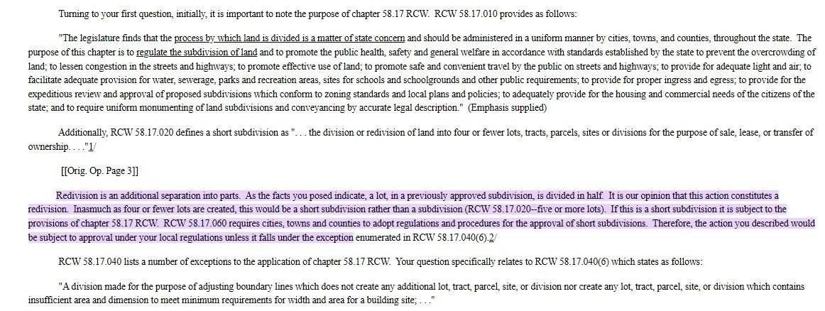
There are, however, specific exemptions in RCW 58.17.040 – situations where certain land divisions are not subject to the full subdivision requirements. For example, cemetery plots are exempt, as are divisions made by court order, and a few other narrow casesatg.wa.gov. One key exemption, found in RCW 58.17.040(6), is for boundary line adjustments (BLAs). A BLA is meant to be a minor alteration of property boundaries between adjoining lots – not creating any new lot, just adjusting lines between existing ones. The law spells this out clearly: a division made for adjusting boundaries “which does not create any additional lot… nor create any lot… which contains insufficient area and dimension to meet minimum requirements for width and area for a building site” is not considered a full “subdivision”seattle.gov. In plain terms, if you and your neighbor agree to move a lot line a few feet one way or the other – perhaps to resolve a fence encroachment or give someone more driveway space – that can be done with a simple BLA, avoiding a plat process. But if the change creates a new lot where there wasn’t one before, or makes either lot too small to build on legally, it’s not a valid BLA and the full subdivision law appliesseattle.gov.
This framework is crucial to understanding the Klickitat controversies. The Greg Wallace/Tract 13 scenario appears to have used an old plat map from the early 1900s (the “North Dalles Fruit and Garden Tracts”) to claim that seven small lots already existed on paper – and by filing a survey, those paper lots were delineated on the ground in 2017. However, if those lots were never lawfully recognized under modern standards, dividing the tract into seven parts now would legally constitute a “short subdivision” (since it’s more than four lots) requiring county approvalatg.wa.gov. Using a survey alone, without a plat, could be viewed as an illegal subdivision. In the Maley/Dallesport case, the question is slightly different: can one rely on an antiquated 1946 plat (Block C of old Dallesport) to create lots today that don’t meet current size or infrastructure standards? And were the 2005 BLAs employed to configure that land done within legal bounds, or did they effectively create new building sites under the guise of “adjustments”?
What State Law Says: Attorney General Opinions Provide Clarity
Fortunately, these exact questions – how old plats and boundary adjustments interact with modern law – have been addressed before. The Washington State Attorney General’s Office has issued several formal opinions over the years interpreting RCW 58.17, which carry persuasive authority in guiding counties. Notably, four Attorney General opinions from 1974, 1980, 1986, and 1996 speak directly to the issues now vexing Klickitat County:
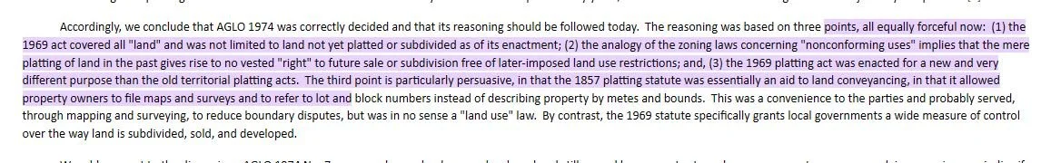
AGLO 1974 No. 7 (an Attorney General’s Letter Opinion from 1974) – This opinion considered an old townsite platted around 1890 that had never been developed. The question was whether a landowner could start selling those 1890-era lots or developing the tract without complying with the 1969 subdivision act. The answer was no: even though the parcel had an ancient plat, the county could “fully apply its then current land use requirements to this old plat, including the requirement that the land be re-subdivided and new plats filed to meet current standards.”atg.wa.govatg.wa.gov In other words, old paper lots are not exempt from modern law. If they were never actually established through sales or development long ago, they must be vetted under today’s rules before being recognized. The 1974 opinion reasoned that earlier platting statutes (in effect when the 1890 map was filed) were minimal and mainly for convenience in describing property, not for regulating land useatg.wa.gov. By contrast, the 1969 law (RCW 58.17) gives local governments broad control to ensure new subdivisions meet health, safety, and infrastructure standardsatg.wa.gov. Simply having lines drawn on an old map doesn’t grant a vested right to ignore later-enacted standardsatg.wa.gov.
AGLO 1980 No. 31 (Letter Opinion, 1980) – This opinion dealt with the duties of county officials when someone tries to record maps or surveys. It made two key points still relevant today: (1) A county auditor can reject a record of survey that doesn’t meet proper surveying requirements or appears to create an illegal plat, and (2) an auditor is actually required by RCW 58.17.190 to refuse recording of any map that “in fact constitutes a ‘plat’ of a ‘subdivision’ required to be filed under chapter 58.17 RCW” if that map hasn’t gotten formal approvalmrsc.org. In simpler terms, if someone tries to record a survey that really is a secret subdivision, the auditor should not accept it. Likewise, county engineers have a duty not to sign off on illicit subdivisions. This opinion resonates strongly with the Greg Wallace case – if indeed a 2017 survey created seven lots, should the county have flagged and blocked it? The law says such maps shouldn’t be recorded without an approved plat. Whether that procedure was properly followed in 2017 is now a point of contention.
AGO 1986 No. 6 (Attorney General Opinion, 1986) – In a scenario very similar to what a “creative” boundary line adjustment might look like, this opinion examined dividing one lot into two pieces and attaching each piece to neighboring properties. Would that be a legitimate boundary line adjustment exempt from platting? The Attorney General’s answer: No. If you cut a lot in half and tack each half onto adjacent parcels, you have effectively created one additional lot (where you used to have one lot, you end up with two separate ownerships) – this is “the creation of a short subdivision” and is not a mere boundary adjustmentmrsc.org. The AG emphasized that such an action is a “redivision” of land and triggers the requirements of chapter 58.17 RCWatg.wa.gov. The only way it could be exempt is if it fell squarely under RCW 58.17.040(6) – which it doesn’t, because a new lot was created and soldatg.wa.govatg.wa.gov. In short, BLAs cannot be used to create new lots, period. They also can’t be used to evade minimum lot size rules – an adjustment that makes a conforming lot become undersized is illegal. (In fact, a later court case in 2006 underscored this: the Washington Court of Appeals in Mason v. King County ruled that RCW 58.17.040(6) “does not allow a local jurisdiction to approve a [boundary] line adjustment that would transform a legally created lot into a substandard, undersized lot.”gigharborwa.gov)
AGO 1996 No. 5 (Attorney General Opinion, 1996) – This modern-era opinion, issued by then-AG Christine Gregoire, reaffirmed the principles from 1974 and extended them. It asked directly: do the requirements of chapter 58.17 (the 1969 Platting Act) apply to land that was platted long ago, even before the first state platting law in 1937? And what about land platted under the 1937 act (which was in effect until 1969)? The AG’s answer: Yes, current law applies to pre-1937 plats “at least to the extent such land has not already been developed.”atg.wa.gov In other words, if you have an old undeveloped plat lying dormant, you can’t suddenly dust it off and develop or sell lots as if it were 1890. You’d need to bring it into compliance with today’s subdivision laws. As for plats from 1937–1969 (which were approved under a regime similar to today’s), the AG said those were generally not invalidated by the 1969 law – local governments may accept them as-is, but are not obligated to without some reviewatg.wa.govmrsc.org. This nuanced point suggests that a 1946 plat like Dallesport’s might be honored, but the county has discretion. If the old lots don’t meet current standards (say, too small for today’s zoning or lacking utilities), the county can require adjustments or replatting to meet modern codesatg.wa.gov. The 1996 opinion stressed that the legislative intent was for the current law to cover all land in the state, not just newly platted landatg.wa.govatg.wa.gov. It also rejected the notion that owners of old platted land have some “vested right” to ignore new regulations – simply having a map from yesteryear is not a shield against present-day rulesatg.wa.gov.
Taken together, these opinions form a consistent message: Antiquated plats do not get a free pass, and boundary adjustments are not a loophole to create new, nonconforming lots. They affirm that the law’s purpose – ensuring thoughtful subdivision design and infrastructure – should not be undermined by clever workarounds. And importantly for Klickitat County’s situation, they indicate that local authorities not only can insist on modern standards, but must be vigilant in how records are handled.
A Pattern of Adjustments: Loophole or Oversight?
Beyond the headline-grabbing cases of Wallace and Maley, Wolfram and others suspect a more systemic issue. They point to data showing an extremely high number of BLAs (Boundary Line Adjustments) recorded in Klickitat County over the decades. According to an analysis Wolfram compiled from county records, 586 BLAs were recorded from 1983 through 2023 – a rate of roughly 14 per year for forty years. By definition, each of those BLAs was approved as an innocuous line tweak that supposedly “does not create any additional lot” and leaves all parcels compliant with size requirementsseattle.gov. But Wolfram questions whether that’s entirely true. “It stretches belief that nearly six hundred adjustments happened with zero new lots sneaking in,” he said. Public records show instances where large parcels were segmented through sequential BLAs, or where slivers of land were peeled off and sold separately, in ways that arguably created new buildable parcels outside the plat process. If even a fraction of the 586 adjustments did this, it could mean unpermitted lots scattered across the county – lots that might be “illegal” under RCW 58.17 and local code.
For example, consider if a 10-acre parcel in a 5-acre zoning area was split into two 5-acre tracts via a BLA (perhaps by involving a neighboring lot to swap boundaries). On paper, it’s an “adjustment,” but functionally it’s a new lot creation – something the Attorney General and courts have said is not allowedmrsc.orggigharborwa.gov. Or if a 1-acre lot in a 1-acre minimum zone was trimmed down to 0.8 acres to enlarge an adjacent lot, the result is a substandard 0.8-acre lot that shouldn’t have been createdgigharborwa.gov. These are the kinds of scenarios that watchdogs suspect have happened. Each would be a violation of the letter and spirit of RCW 58.17.040(6) and the county’s own ordinances.
County planning officials have not yet provided a detailed breakdown of those 586 BLAs – how many were simple neighborly swaps versus how many might have been used to create new building sites. It’s possible many were perfectly benign. But the sheer volume, combined with the specific cases now in the spotlight, has eroded public trust. “Either the county wasn’t paying close enough attention, or some folks found a loophole and ran with it,” said a former county planner who spoke on condition of anonymity. “Boundary line adjustments are supposed to be dull, technical filings. If they’ve been misused, it didn’t happen in a vacuum – it means oversight failed somewhere.”
County Auditor Brenda Sorensen and Planning Director Mochi Lindblad have both indicated that they are reviewing past practices in light of the recent complaints. Sorensen’s office, which handles the recording of land surveys and plats, is crucial in this process – as AGLO 1980 No. 31 noted, the Auditor must reject maps that amount to unapproved subdivisionsmrsc.org. Sorensen said her staff follow the law, but also rely on information provided by surveyors and the planning department about whether proper approvals have been obtained. “If a record of survey comes in, we check if it references an approved plat or exemption,” she explained at a meeting in late 2023. “We don’t have a crystal ball to know the intent behind every line adjustment.” Lindblad added that since taking the helm of the Planning Department in 2019, she has tried to tighten procedures. “We treat any proposal that walks like a subdivision as a subdivision,” she noted, “even if someone calls it a ‘lot line fix’.”
Nevertheless, both officials acknowledge that some historical adjustments might warrant a second look. The county commissioners have the authority to direct a review or audit of past land divisions if needed. Citizens like Wolfram are calling for exactly that – a comprehensive audit of the 586 BLAs to identify any that created illegal lots, and a plan to address them. “If a lot was improperly created, it puts the owner in a tough spot and the county in legal jeopardy,” Wolfram says. “It’s best to sort it out sooner than later.”
Oversight, or Systemic Issue?
As this debate unfolds, opinions differ on whether the problem stems from bureaucratic oversight (i.e. mistakes and gaps in enforcement) or a deeper systemic issue with how the county has been doing business. Some argue that county staff were simply overburdened or not fully trained in the legal nuances. In a fast-growing county, land transactions can fly under the radar, especially if presented in innocuous terms like “boundary adjustment” or if relying on decades-old plat maps that lurk in back-filed records. “I suspect there wasn’t any willful wrongdoing inside the county,” said one retired county attorney. “It was more that these were technical issues that maybe weren’t fully appreciated, and people got lax.”
But others see a more troubling pattern. They note that some beneficiaries of these questionable land splits are influential landowners or developers. Greg Wallace, for instance, is a prominent figure locally, known for multiple projects. William Maley likewise is a long-time property owner in the area. “It’s hard not to wonder if there was a wink and a nod at play,” a resident commented at a recent Dallesport community gathering. There is also speculation that the county informally favored using BLAs to allow some development that would otherwise be blocked by zoning or plat requirements – essentially, a “don’t ask, don’t tell” policy to spur growth or property sales in a rural county hungry for tax base. No official has admitted to any such stance, and commissioners strongly deny that any improper approvals are condoned. “We follow the law and apply it equally,” Commissioner Dan Snyder said at a meeting, stressing that any specific allegations of illegal lot creation will be investigated.
The truth may lie somewhere in between. It’s possible that for years, adjustments were handled on a case-by-case basis without a clear eye on the cumulative effect. One BLA creating a substandard lot might slip through; a second might involve the same parties and also slip through, and so on, until a problematic precedent set in. Only now, with the benefit of hindsight and the push from concerned citizens, is the extent of the practice coming to light.
Moving Forward: Calls for Transparency and Compliance
In the wake of these revelations, there are growing calls for transparency, compliance, and stronger oversight of land divisions in Klickitat County. Citizens like Steve Wolfram are urging the Board of County Commissioners to hold public workshops explaining how subdivisions and BLAs are supposed to work, and to openly address the past cases. “Sunlight is the best disinfectant,” Wolfram said. He has asked the county to publish a list of all BLAs in the past 40 years and indicate which created parcels smaller than current zoning allows. Additionally, local advocacy groups want an independent review (perhaps by state officials or a land-use expert) of the Wallace and Maley cases to see if errors were made and how to prevent repeats.
Legal compliance is another emphasis. Critics are pressing the county to strictly enforce RCW 58.17 going forward – meaning no new lots by survey alone, no recognition of ancient plats without proper replatting, and no BLAs that don’t meet the letter of the law. They also suggest updating county code if needed to close any ambiguity. For instance, some counties explicitly require any “BLA” to not result in lots that violate zoning minimum sizes, mirroring the Mason v. King County case holdinggigharborwa.gov. Ensuring that surveyors and landowners are aware of these rules is part of the challenge. “Education is key,” noted Planning Director Lindblad. “If people know up front that trying to create a lot on the sly will backfire, they’re less likely to attempt it.”
County leaders appear to be taking the issue seriously. In a recent session, one commissioner floated the idea of a temporary moratorium on accepting new BLAs in certain high-growth areas until the review is complete – to prevent a rush of last-minute filings. Another suggested requiring a second set of eyes (like the Prosecuting Attorney’s Office) to review any complex boundary adjustments. These ideas will likely be discussed in upcoming meetings.
Ultimately, the controversy may prove to be a turning point for how Klickitat County manages growth. As the county’s population increases and development pressure mounts, having clear and fair land division practices is critical. Longtime residents value the area’s rural character and want rules against haphazard lot splits enforced to protect water, roads, and open space. Newer residents and developers, on the other hand, seek predictability and a level playing field – knowing what is and isn’t allowed. Both groups stand to benefit from a system where subdivisions are done above-board, with public input and adherence to the comprehensive plan.
In closing, what was once an esoteric topic buried in land records has become a cause célèbre for local government accountability. Credit goes to Steve Wolfram, whose persistent public questioning helped bring these issues to light. His efforts underscore how a single citizen’s voice can prompt a community to re-examine the fine print of its policies. The challenge now is translating that awareness into action.
Klickitat County’s code and the state RCWs are clear on paper; the task ahead is to ensure they are followed in practice. As the county moves forward, residents will be watching closely. The hope is that this moment leads to greater transparency, rigorous compliance with land use laws, and renewed commitment to responsible oversight – so that every new lot in Klickitat County’s future truly meets the test of legality, safety, and community trust.