
Fire Updates: July 28, 1 p.m.: Grasshopper Fire grows by 3,000 acres south of Dufur
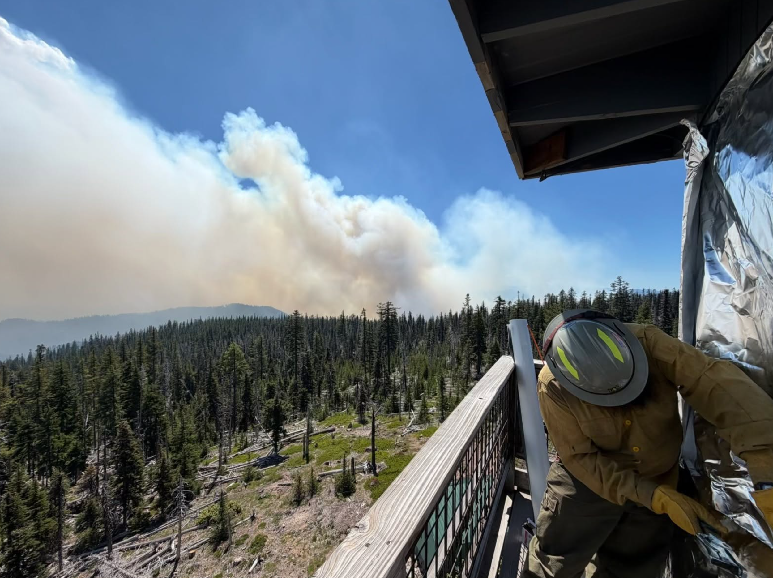
Photo from Grasshopper Fire’s Facebook page.
From Grasshopper Fire and Wasco County Sheriff releases with edits by Tom Peterson
The Dalles, Ore., July 28, 2026 — The Grasshopper Fire has grown to 13,612 acres, an increase of about 3,000 acres since Monday, as firefighters continue working to strengthen containment lines and protect threatened communities, according to the Grasshopper Fire Information Facebook page.
The fire, burning between between Mt. Hood and Maupin, remained active Monday, particularly within the Badger Creek Wilderness, where steep terrain and heavy fuels contributed to increased fire behavior. Despite the challenging conditions, firefighters established containment line along the southeast corner of the fire and continued holding and strengthening lines along the southern edge, especially near Forest Road 4810.
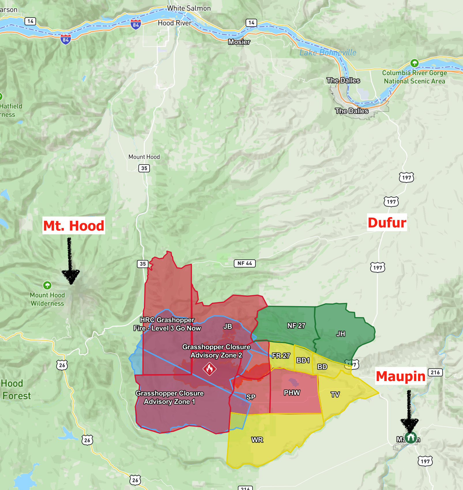
Grasshopper Fire location and evacuation map
Aircraft remained a key part of the firefighting effort, with fixed-wing scoopers and helicopters making water drops throughout the day. Overnight crews continued securing fire lines near the perimeter while supporting Oregon State Fire Marshal task forces assigned to structure protection.
The Oregon State Fire Marshal continues providing structure protection for the communities of Sportsman's Park and Pine Hollow, with those resources expected to remain in place as long as needed.
On Tuesday, firefighters and heavy equipment crews were assigned to continue constructing fire line along the west side of the incident. Crews on the southern flank are focused on mopping up completed line and scouting locations for contingency fire lines, while personnel on the eastern perimeter are evaluating additional opportunities for containment while maintaining existing control lines protecting nearby communities.
A Complex Incident Management Team was expected to arrive Tuesday and assume command of the fire following a transition period with the current incident management team, according to the Grasshopper Fire Information Facebook page.
As of Tuesday morning, the fire response included approximately 200 personnel, 32 engines and 15 pieces of heavy equipment.
The National Weather Service forecast calls for cooler temperatures Tuesday, with highs near 80 degrees in the Dufur area and northwest winds of 11 to 18 mph, with gusts up to 25 mph. A warming and drying trend is expected through the remainder of the week, with highs climbing into the low 80s Wednesday and Thursday. Fire managers also noted that the Northwest Coordination Center has issued a Fuels and Fire Behavior Advisory that includes the Grasshopper Fire area.
According to the Wasco County Sheriff's Office, evacuation levels for the Grasshopper Fire remained unchanged Tuesday afternoon. Level 3 "Go Now" evacuations remain in effect for the Grasshopper Advisory Zone within the Mount Hood National Forest, along with Sportsman's Park, Pine Hollow and Wamic. Level 2 "Be Set" evacuations remain in place for Smock Road, White River Crossing, Badger Creek, Shadybrook Road and Tygh Valley. Level 1 "Get Ready" notices remain in effect from Forest Road 27 to Friend Road and from Elliott Road to Friend Road and Highway 197.
A shelter for evacuees remains open at Maupin High School, 699 Fourth St., Maupin. The Sherman County Fairgrounds, 66147 Lone Rock Road in Moro, continues serving as a large-animal shelter.
A closure order remains in effect for portions of the Mount Hood National Forest surrounding the fire. Officials continue to urge residents to monitor changing evacuation levels through the Wasco County Sheriff's Office interactive evacuation map and Citizen Alert notification system.
Separately, U.S. Rep. Cliff Bentz announced that the Federal Emergency Management Agency has approved Oregon's request for a Fire Management Assistance Grant for the Grasshopper Fire. According to Bentz, FEMA determined the wildfire had the potential to become a major disaster after it threatened nearly 700 homes, along with commercial and residential buildings, electrical utilities, campgrounds, trails, Bureau of Land Management roads, and radio and cellular communication facilities serving the communities of Tygh Valley, Wamic, Pine Hollow and Sportsman's Park. The approval makes Oregon eligible for reimbursement of up to 75% of qualifying firefighting costs, including expenses for personnel, equipment, materials and mobilization.
8-Mile Fire
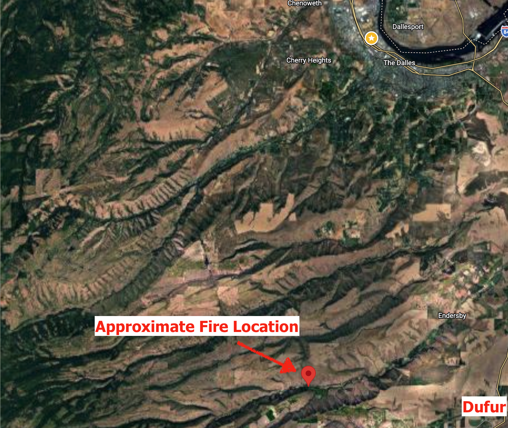
The 8-Mile Fire, burning about 5 miles west of Dufur, remains at 532 acres and is now 80% contained, according to the Wasco County Sheriff's Office and the Oregon Department of Forestry.
The fire started July 24 and received an aggressive initial attack from ODF, mutual-aid agencies, aircraft, contract resources and local landowners. Firefighters stopped the forward spread the first night and have continued strengthening containment lines and mopping up hotspots. No evacuation zones remain in effect.
10-Mile Fire and 586 Fire
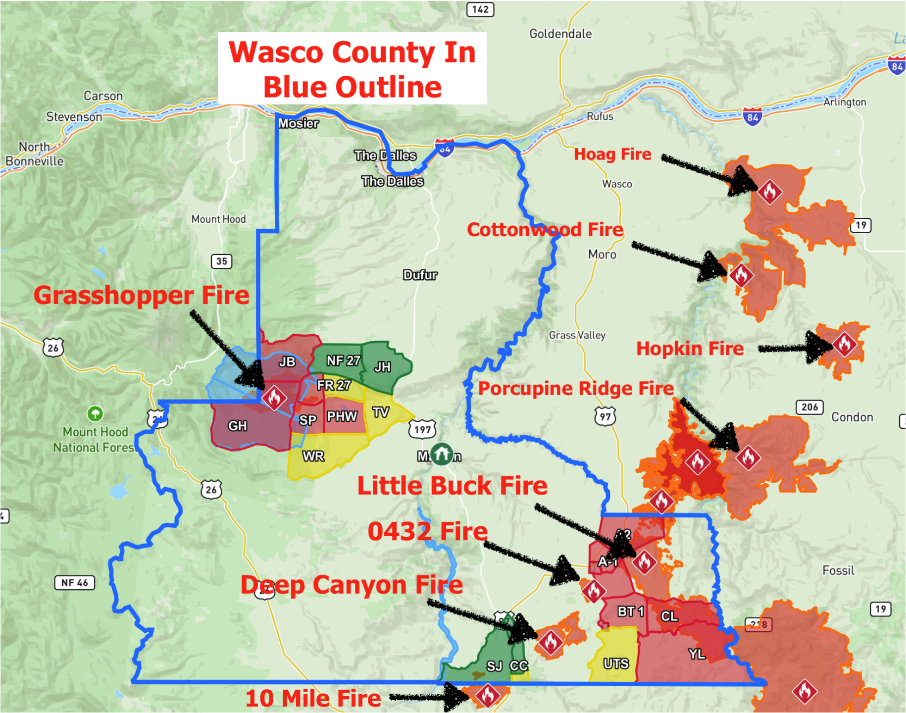
The 10-Mile Fire, burning near the Jefferson County and southern Wasco County border, remains at 4,834 acres, while the adjacent 586 Fire, caused by lightning, remains at 191 acres, according to the Wasco County Sheriff's Office.
Emergency managers announced additional reductions in evacuation levels Tuesday. Areas previously under Level 2 "Be Set" have been reduced to Level 1 "Get Ready" along Highway 97 from the Wasco-Jefferson county line to the Antelope Highway intersection, Highway 293 to Milepost 3 and the Jefferson County line. Other Level 1 evacuation notices south of South Junction Road and portions of Highway 97 and Highway 197 have been lifted.
The Bureau of Land Management continues to restrict access to public lands, boat launches, access points and backcountry campsites along the Deschutes River from the Warm Springs launch at Highway 26 to the locked gate on the Deschutes River Access Road.
Little Buck Fire
The Little Buck Fire, part of the Hay Creek Complex, has grown to 36,003 acres, according to the Wasco County Sheriff's Office.
Evacuation levels were reduced Tuesday, with Level 3 "Go Now" notices lowered to Level 2 "Be Set" for Shaniko, Highway 97 from Shaniko to the Sherman County line, Antelope, Bennett Road, Young Life and Clarno. Areas previously under Level 2 from Upper Tubbs Road to Cold Camp Road were reduced to Level 1 "Get Ready."
Deep Canyon Fire
The Deep Canyon Fire has burned approximately 8,089 acres, and all Level 1 evacuation notices have been lifted, according to the Wasco County Sheriff's Office.
Emergency Management Services Manager Sheridan McClellan urged residents to continue monitoring official sources for the latest evacuation information, noting that fire conditions can change rapidly. Residents can check current evacuation levels through the Wasco County Sheriff's Office interactive map, sign up for Citizen Alert notifications through Wasco County Emergency Management, and follow official wildfire updates from local, state and federal agencies.

Support Local News!
Available for Everyone; Funded by Readers.