
Grasshopper Fire jumps to 61% containment as crews secure more of 92,408-acre blaze
By Joshuah Albert
The Dalles, Ore., Aug. 19, 2026 — Containment on the Grasshopper Fire jumped to 61% Wednesday, marking another major gain as firefighters increasingly secure the sprawling fire's northeastern, southern, and Highway 35 boundaries.
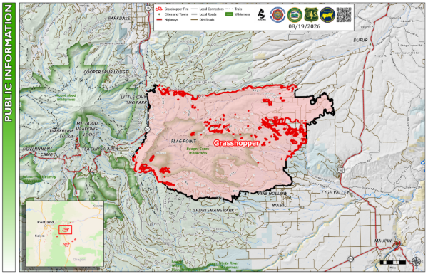
The fire is now mapped at 92,408 acres, up from 90,768 acres Tuesday, with 1,761 personnel assigned to the incident.
Fire officials said the increase in acreage was partly the result of infrared flights identifying previously unburned pockets of vegetation well within the existing fire perimeter that have since burned. The higher acreage therefore does not represent an equivalent amount of new outward fire growth.
Containment increased from 49% Tuesday to 61% Wednesday as fire managers gained confidence in control lines along the northeast corner.
Tuesday's potentially critical fire weather also proved less severe than anticipated, with winds remaining below forecast speeds.
Along the north and northeast, the fire maintained its existing footprint as control lines along Forest Road 4421 and Logging Gulch Road continued to hold.
Tiny heat spots found outside northwest line
Infrared-equipped drones detected several small heat signatures outside the northwest control line near Cooks Meadow.
Fire officials described the spots as no larger than a dinner plate. Firefighters conducting mop-up in the area quickly extinguished them.
Along the Highway 35 corridor, containment continued to hold with no additional heat detected outside the line.
Drone operations were also used to eliminate pockets of unburned vegetation between the fire and control lines near The Dalles Watershed. Officials said those operations, designed to further protect the watershed, have now been completed.
Smoke will remain visible from surrounding communities as islands of vegetation continue burning inside the fire perimeter. Officials emphasized that those interior pockets do not necessarily indicate increased fire spread.
Mop-up reaches deeper into eastern flank
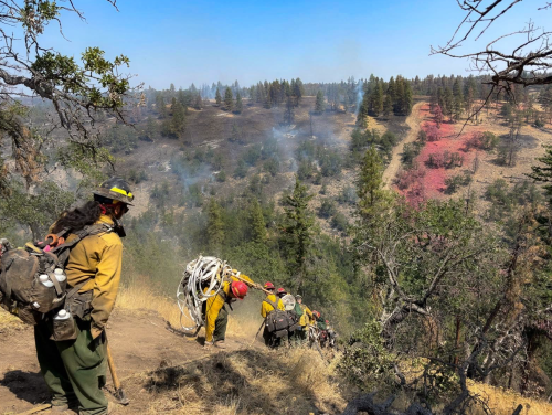
With more of the perimeter secured, much of the firefighting effort is increasingly centered on methodical mop-up.
From Friend Road through Kingsley Road, Shadybrook Road and the Tygh Creek drainage, crews have secured about 50 feet of mop-up depth and are working toward a goal of 200 feet.
That involves firefighters moving progressively farther inside the burned area, searching for and extinguishing residual heat around roots, stumps, logs and other fuels that could potentially rekindle.
Structural crews are continuing aggressive mop-up around homes, but officials said heat detections are becoming less frequent each day. Additional control lines have also improved defensible space around structures in the Shadybrook area.
The southern end of the fire has progressed to patrol status, with crews reporting no additional heat while removing fire-damaged vegetation, fallen trees and debris.
Specialized equipment gains ground on steep southwest flank
Crews also reported significant progress in one of the most difficult sections of the fire.
High-line equipment operating on the southwest corner installed approximately 1,500 feet of fireline through steep terrain, putting that operation ahead of schedule.
The specialized machinery is tethered with heavy cables, allowing it to operate on slopes too steep for conventional heavy equipment.
Operations near Crane Prairie, north of Bonney Meadows, are now progressing through slopes approaching 80 degrees.
Hand crews will connect the newly constructed line with existing trail systems, helping prevent the fire from moving upslope and closing another gap in the containment network.
Another weather change expected this weekend
Warm, dry conditions will continue Wednesday, although winds are expected to be lighter than Tuesday and largely influenced by local terrain before shifting northwesterly during the late afternoon and evening.
Fire managers are also watching another weather system expected late Friday into Saturday.
A dry cold front could bring stronger west-to-northwest winds and a small chance of thunderstorms before conditions return closer to seasonal norms.
Evacuation notices ranging from Level 1 "Be Ready" through Level 3 "Go Now" remain in portions of Wasco, Hood River and Clackamas counties. Residents should continue checking current evacuation information through the Wasco and Hood River counties evacuation map.
The evacuation shelter remains open at The Dalles Middle School, 1100 E. 12th St.
A closure remains in effect on portions of the Mt. Hood National Forest, along with a Temporary Flight Restriction over the fire.
Motorists traveling Highway 35 should continue watching for firefighters, heavy equipment and hazard-tree removal operations and can check current conditions through Oregon TripCheck.
Support Local News!
Available for Everyone; Funded by Readers.