
Grasshopper Fire surges to 77,311 acres; crews move to protect homes southwest of Dufur

View from the seat of a bulldozer maintaining the fireline along the eastern edge of the Grasshopper Fire last night. To see the full video click here. Image and video courtesy Grasshopper Fire facebook page.
UPDATE: Tygh Valley has been upgraded to Level 2 – BE SET, according to the Wasco County Sheriff’s office at 12:15 p.m. today, Aug. 11. Conditions may worsen rapidly — be prepared to leave at a moment's notice, and evacuate immediately if you feel unsafe.
The Dalles, Ore., Aug. 11, 2026 — The Grasshopper Fire exploded to 77,311 acres overnight as increased fire activity pushed toward populated areas southwest of Dufur, prompting changing evacuation levels and the deployment of Wasco and Hood River county task forces to protect homes and property.
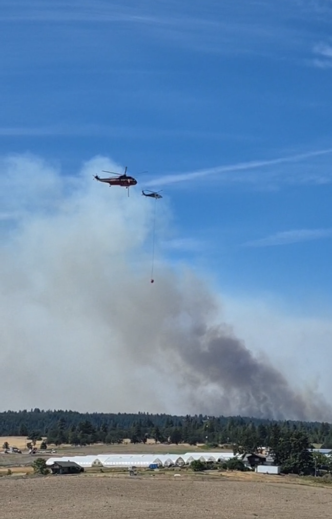
Helicopters working to stem the blaze at Dufur and Wolf Run Roads several miles east of Dufur. Live footage taken at 11:10 a.m. today, Aug. 11. Go to https://www.facebook.com/columbiacommunityconnection/ for live coverage
The fire was listed at 20% containment Tuesday morning with 1,680 personnel assigned, according to the Grasshopper Fire Quick Facts page.
That represents an increase of 13,652 acres from Monday evening, when the fire was reported at 63,659 acres and 23% contained. Fire officials cautioned Monday night that those figures were several hours old and would not be updated until acreage and containment could be verified Tuesday morning.
Fire officials said the blaze was “very active” overnight and that multiple evacuation levels changed as conditions developed.
The increased activity also brought the fire closer to populated areas.
At approximately 8:30 p.m. Monday, Aug. 10, structure protection task forces from Wasco and Hood River counties were requested to immediately respond to the Grasshopper Fire as activity increased near Friend Road and areas southwest of Dufur, according to Mid-Columbia Fire and Rescue.

Wasco County and Hood River County structure protection task forces were requested for immediate assistance on the Grasshopper Fire as fire activity increased near populated areas along Friend Road and and areas southwest of Dufur. Photo courtesy Mid-Columbia Fire and Rescue.
Both regional task forces responded and were assigned to structure protection operations, working with other firefighting resources to prepare and defend homes and property if the fire continued to advance.
Evacuation levels expanded as Grasshopper Fire advances
On Aug. 10, evacuation levels were changed Monday as increased activity on the Grasshopper Fire threatened areas of Wasco County, according to county emergency officials.
Level 3 — Go Now evacuations were in effect for the following zones: Sportsmans Paradise (SPA), Shell Rock Road (SH), South Valley Road (SVR), Wolf Run Road (WRR), Ward Mill Road (WM), Rail Hollow (RD), Hix Road (HH), Friends (SCH), J Hix (JH) and Dufur Gap Road (DR).
Residents in Level 3 areas should leave immediately.
Level 2 — Be Set evacuation notices were in effect for the city of Dufur (DF), Fargher Road (FRG), Tygh Ridge Road (TRR), Hulse Road (HSR) and Pine Hollow (PHR).
Residents in Level 2 areas should be prepared to leave at a moment’s notice and continue monitoring official evacuation information.
Evacuation levels can change rapidly as fire conditions develop. Residents should follow the Wasco County Sheriff’s Office and Wasco County emergency management officials for the latest information.
Battle Continues
Firefighters had already been engaged in structure protection Monday evening along the northeastern edge of the fire as activity increased in that area.
Heavy equipment was also working overnight to construct and improve firelines. Fire officials shared video from a Type 2 dozer (see above) operating on the eastern edge of the fire during the night shift.
The overnight expansion marks another significant escalation for the Grasshopper Fire, which began July 23 near the Badger Creek Wilderness and has since grown into a major wildfire in Wasco County.
The reported containment decreased from 23% Monday evening to 20% Tuesday morning. A decline in the containment percentage can occur as a wildfire grows because newly expanded portions of the fire perimeter may not yet have containment line established around them.
Officials urged residents to remain alert as evacuation conditions continue to change and to follow evacuation notifications when issued.
Residents should follow the Wasco County Sheriff’s Office and Wasco County for the latest evacuation information and maps. Fire officials also urged residents to sign up for county emergency alerts.
Additional information on fire activity, evacuations and firefighting operations was expected later Tuesday.