
Fire Round Up: Boulder still a smolder; Deschutes and The Devil die down

Boulder Fire briefing today, July 14. Firefighters are using the Rock Creek OHV Area as a staging area. For everyone’s safety, the public is asked to stay clear of these fire suppression operations.
Photos from NW Incident Mgmt. Team 10
By Tom Peterson
Boulder Fire
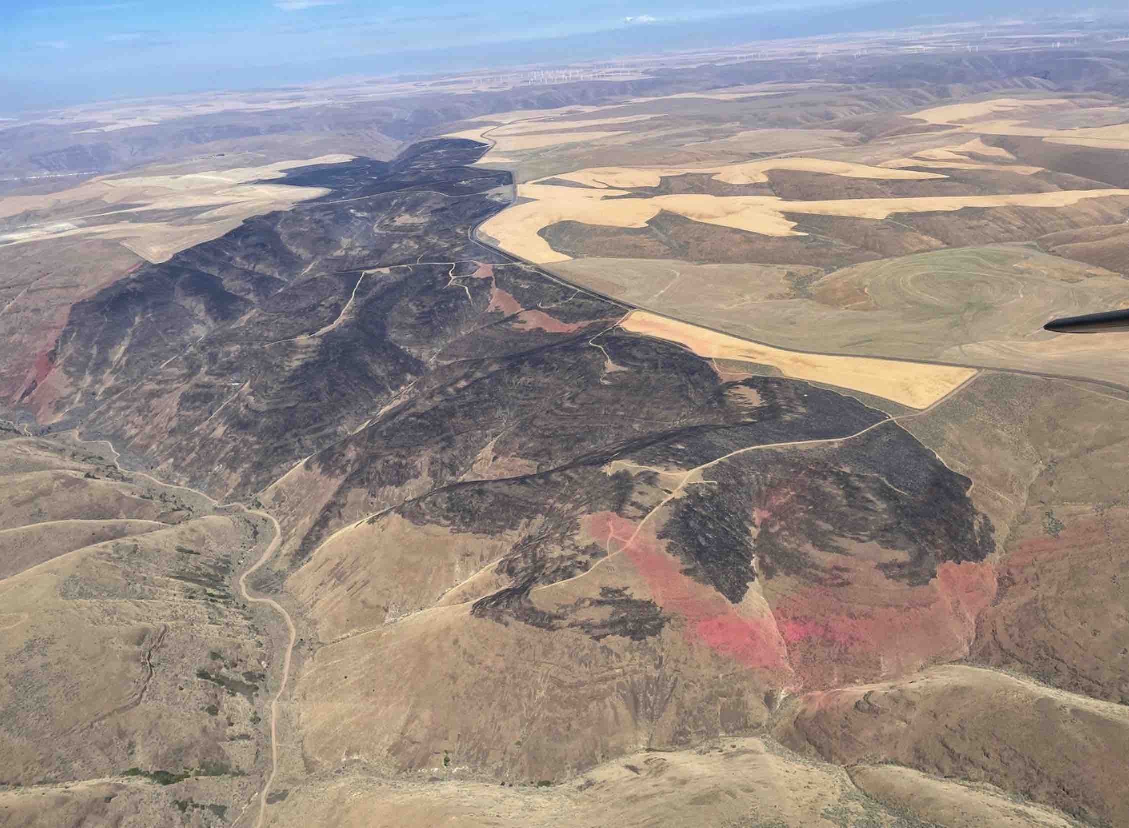
The Dalles, Ore., July 14, 2023 - Fire managers have reassessed the total acres burned in the Boulder Fire 26 miles southwest of Dufur, Oregon after receiving improved mapping data.
The estimate now stands at 238 acres. The fire is burning in dead and down timber debris in steep, rugged and alpine-like terrain.
Here is the most recent aerial image of the Boulder Fire - Boulder Lake at center. Click to enlarge.
A total of 409 personnel, including 7 handcrews, are working at building fire breaks around the blaze.
Fire managers are also using 7 fire engines, 8 water tenders, 7 helicopters, 8 pieces of heavy equipment and one plane in an attempt to surround and contain the fire.
“The past week’s hard work has resulted in less active fire, and firefighters can focus more on mop-up operations,” the Northwest Incident Management Team 10 reported this morning. “As of last evening, the percentage of containment had increased to 10%.”
On Thursday, July 13, “fire crews completed containment lines and hose lays along the western flank. They used hand tools and water from the network of hose lines placed over the past few days to extend containment lines over 10 feet within the fire’s edge,” the report states. “Firefighters also cut off heat sources by attacking pockets of fire directly. Fire crews finished two-thirds of the containment lines on the eastern flank. In the remaining one-third on the southeastern corner, crews searched for hot spots and found none in a systematic process called ‘gridding.’”
“Today, an unmanned aerial system (UAS) equipped with thermal-imaging equipment is expected to arrive. Fire managers will use the UAS information to more effectively locate hotspots in the area’s thick underbrush. Firefighters will continue mop-up, working to create 10 to 50 feet of cold and fuels-free line around the fire perimeter.”
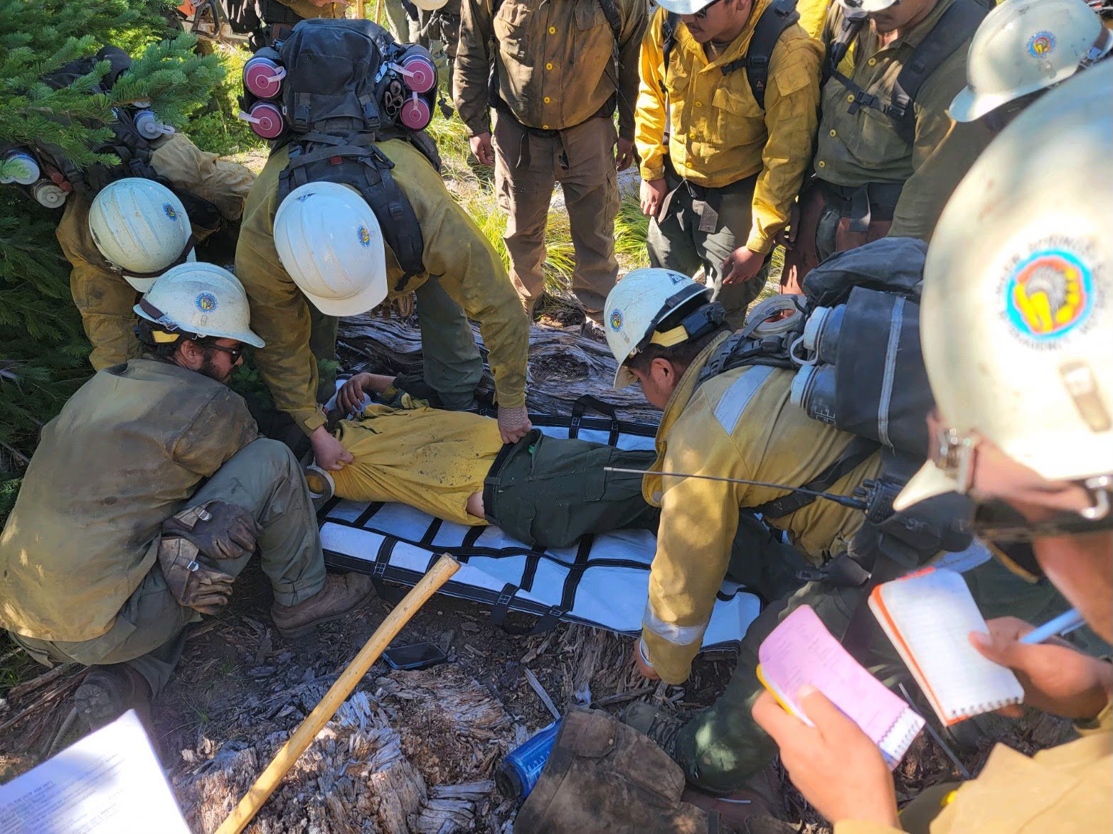
Practice in the field - Firefighters train on how to assist an injured firefighter.
Also on July 13, fire managers and a small group of firefighters participated in a successful Incident-Within-An-Incident (IWI) drill to exercise the incident management team’s procedures for when a crew member is injured. While there have been no injuries in this incident, it is vital that the team’s emergency skills remain sharp.
Weather
Today is expected to be warmer and drier than yesterday with light terrain-driven winds. Conditions are forecast to continue warming and drying through the weekend.
Closures and Restrictions
Many of the roadways, campgrounds and trails north and east of Forest Road 48 in the Barlow Ranger District are closed. Due to the high fire danger, open fire and target shooting restrictions have been implemented. For more information or to view the full closure order, visit the Forest webpage at www.fs.usda.gov/alerts/mthood/alerts-notices.
Evacuations
Boulder Lake Campground, Little Boulder Lake, Bonney Meadows Campground, Badger Lake Campground, Camp Windy, and Post Camp Campground are under a Level 3 –Go Now evacuation. Evacuation levels are Level 1 – Be Ready to Evacuate, Level 2 – Be Set to Evacuate, and Level 3 – Go Now. More information is available from the Wasco County Sheriff’s Office at www.facebook.com/WascoCountySheriff.
Sherman County Sheriff’s Office captured this image of the fire on July 13 from the Highway 30 bridge looking south past Heritage Landing and the developed portion of Deschutes State Park. Click to enlarge.
Deschutes River Fire
The Dalles, July 14, 2023 - Sherman County Emergency Services reported this morning that the fire near the mouth of the Deschutes River that has burned some 1,000 acres in steep scrub and grass range is contained but not out.
Crews from ODF, Prineville BLM, land owners, North Sherman Fire, Moro Fire, and South Sherman Fire have the fire contained but not out at this time, the report states.
On Thursday, July 13, the Sherman County Sheriff’s office reported the fire was caused by a camp stove that tipped over a few miles south of the developed section of Deschutes State Park, which lies near the river’s mouth. It was burning north towards the park.
Backpackers and anglers often utilize the first three miles of the riverbank, often times camping at Knock Knock or near Colorado rapid as boats are not allowed to pull over in the last three miles of the river, which is beyond Rattlesnake Rapids.
“Deschutes Park, which remains closed at the time for public safety, “ Emergency services reported this morning.
The park has a total of 62 campsites in the developed portion of the park, and it is in it’s busiest season.
Fire officials said additional resources will arrive today to relieve local resources. However, local resources will return later today as needed.
Fire managers are asking the public to please stay clear of the Deschutes River Fire and allow firefighters to work.
“A very big thank you to our land owners and patterns for the teamwork and diligence in helping contain the Deschutes Fire,” the report stated.
This image of the Devils Butte Fire shows how the fire was contained to one side of Highway 206 in the early fight. The Fire now appears to be in the latter stages of mop-up.
Devils Butte Fire
The 2,865-acre blaze started by lightning about 8 miles southwest of Cottonwood Canyon State Park appears to be in mop-up, according to locals.
Farmers, ranchers, and firefighters appear to have the lightning-caused Devil’s Butte Fire under mostly under control on Tuesday, July 11.
The fire burned in wheat and rangeland in the plateaus and rugged canyons near the John Day River 40 miles southeast of Biggs Junction. Fires such as these when pushed by heavy wind can last days if not weeks under hot dry conditions.
But not this time.
Flame retardant from planes, as well as plowing discs and shovel work, paid off.
Katie Cook who lives adjacent to the fire on Ajax Road reported that the fire took out power poles during the blaze, cutting the electricity to the town of Condon, population 700, 20 miles to the south.
In addition, the fire destroyed two fire trucks from South Gilliam Fire Department and North Gilliam Fire Department after they were overrun by wind-driven fire. Winds were gusting about 30 mph on Monday. Fortunately, no firefighters were injured.