
Microwave Fire burns down to I-84 on Sunday; fire near Mosier is 53% contained
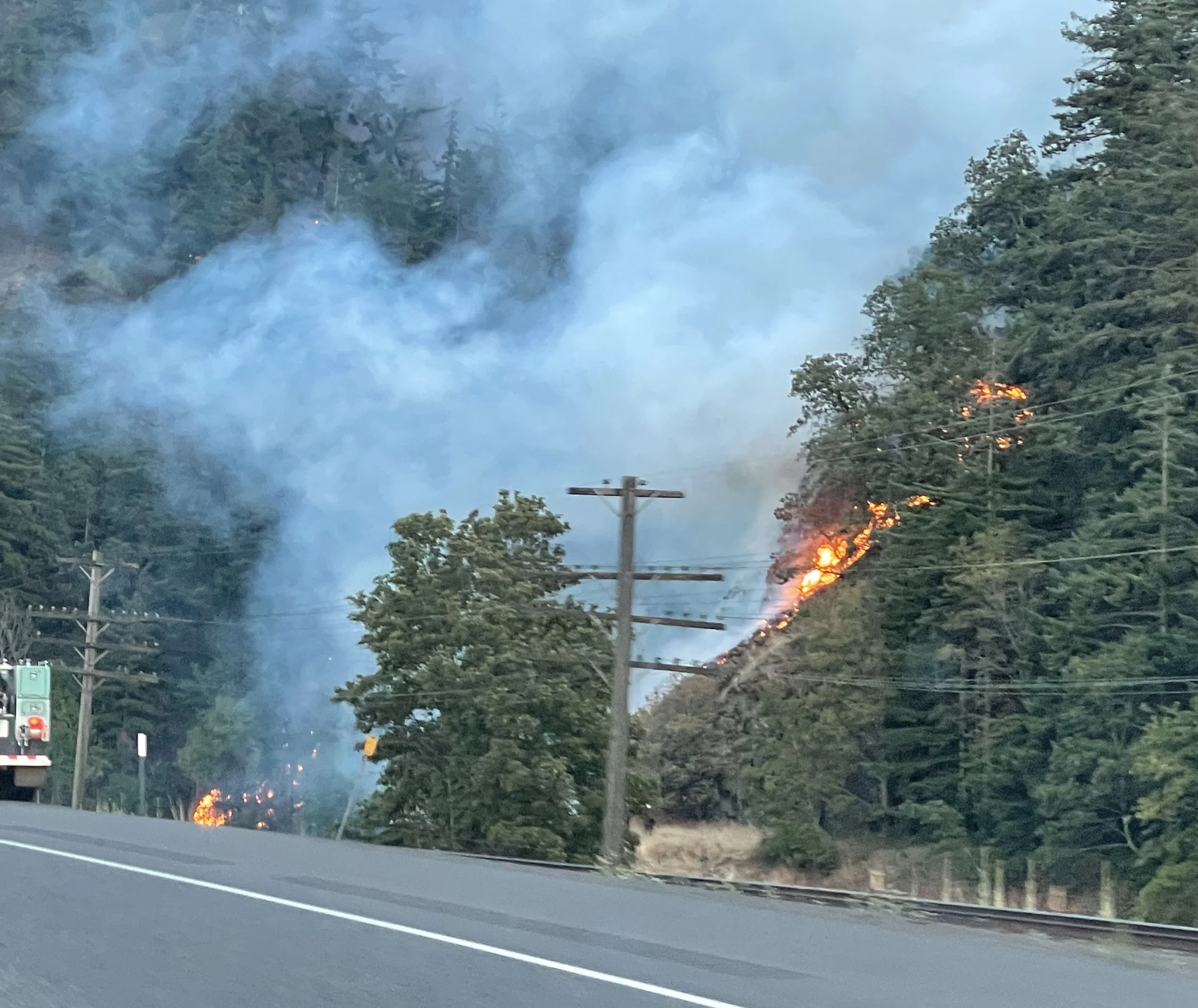
Derek Fasulo captured this image of the fire next to I-84 on Sunday evening, July 28.
The Dalles, Ore., July 29, Noon — The Microwave Tower Fire expanded into another 400 acres as it burned during the weekend, burning down cliffs to Interstate 84 on Sunday.
The fire burning west of Mosier is now estimated at more than 1,300 acres but is also 53 contained as 126 fire personnel continue to dig in against the fire.
“Yesterday, helicopters, scoopers, dozers, engines and crews worked on the north side of the fire to stop the fire’s growth to the east and west below the historic Columbia River Highway State Trail,” stated a press release from the Central Cascades Interagency Management Team. “Along the northwestern flank, aircraft dropped water to support hotshot crews as they built a direct line down to I-84. On the northeastern flank, slopes are steep, and aircraft supported crew efforts to tie in a line from Old Highway 30 to I-84.”
“The fire has reached the highway, and the driving public is asked to use extreme caution on I-84 as firefighters and aircraft work in this area. Portions of I-84 were temporarily shut down as helicopters delivered water from the river to the fire.”

Photo by Nick Anderson
“Today, crews will install a hose lay and begin mopping up to secure the northwest line. Aircraft will be used to cool hot spots along the northeastern edge. No fire spread occurred along the contained lines on the eastern, southern, and western edges. Crews will patrol these areas.”
The Central Cascades Interagency Management Team, led by Incident Commander Jeremy Goers, assumed command of the Microwave Fire at 6:00 a.m., Monday, July 29, 2024.
Fire Behavior
Cloud cover and higher relative humidity will help moderate fire behavior on the northern flank with minimal fire behavior along all other flanks. Expect increased smoke production. Fire activity has the potential to impact surrounding communities as well as the I-84 and Union Pacific railroad corridors.
Fire evacuation map. Click on the image to enlarge it.
Evacuations remain in place today for Wasco and Hood River Counties.
LEVEL 3 - GO NOW! Evacuate immediately from Hwy 30 south to Hood River Rd., east to Rock Creek and Huskey Rd., and west to the Hood River County line.
LEVEL 2 - GET SET
• from the border of Hood River and Wasco County, south to the Historic Columbia River Highway State Trail, and west to the intersection of Highline Rd. and Old Columbia River Dr., and north to the Columbia River.
• for the City of Mosier from Rock Creek, east to Mosier Creek Rd., south to the intersection of Huskey Rd. and Ponderosa Place and Blanchard Blvd., and west to Rock Creek.
• From the Hood River County border in the west, east to Huskey Rd., southwest to the intersection of Huskey Rd. and Elder Rd., and north to just south of Hood River Rd.
LEVEL 1 - GET READY
• from Huskey Rd. southwest to Elder Rd, east to Dry Creek Rd. and Osborn Cutoff Rd., and north to the City of Mosier border.
• from the intersection of Hwy 35 and Hwy 30, south to the intersection of Eastside Rd and Paasch Dr., east to Elder Rd. and north to Historic Columbia River Highway State Trail.
Hood River Rd. and the Columbia River Highway State Trail are closed due to firefighting efforts. Some roads also remain closed in Hood River County. Please refer to the map for additional information.
Additional Information
Facebook: https://www.facebook.com/2024MicrowaveTowerFire/
InciWeb:https://inciweb.wildfire.gov/incid.../or954s-microwave-tower

Support Local News
Available to everyone. Funded by readers.