
Winter Storm Brings Snow to the Cascades, Heavy Rains to PNW on Friday
Updated November 12th 11:00 PM
Local Weather Service, Temira's Awesome Travel Advisory Service, has reported:
“Chaos in the form of extreme mountain snowfall still manifests, but the hurricane force wind is 85% gone from the ensembles. Welcome to La Nina – extreme weather, rapid model changes, and plenty to keep you on your toes, dancing around like a five year old ballerina in the Nutcracker.”
“Friday: no more extreme blizzard for the mountains. No more extreme windstorm for the Willy Valley or the Gorge. All we get now is your typical Mt. Hood blizzard and typical Gorge windy day. Rainbows, however... they'll be atypically bright and doubled given the heavy rainfall, wind, and sunbreaks.
“Mellower weather arrives on Saturday. Scattered showers and sprinkles under partly cloudy sky in the west and dry, sunny weather east of Hood River. Clouds and rain return for the evening. Sunday looks rainy.”
See the full weekend weather report from Temira’s Awesome Travel Advisory Service.
Updated November 12th 10:00 AM
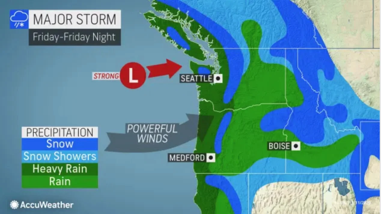
Winter weather is coming to the PNW this Friday the 13th. The storm is predicted to bring high winds, heavy rains, and snow to Oregon and Washington.
The storm will be the first snow storm in the PNW this winter and will be the strongest seen in months, meteorologists with AccuWeather told The Associated Press on Wednesday.
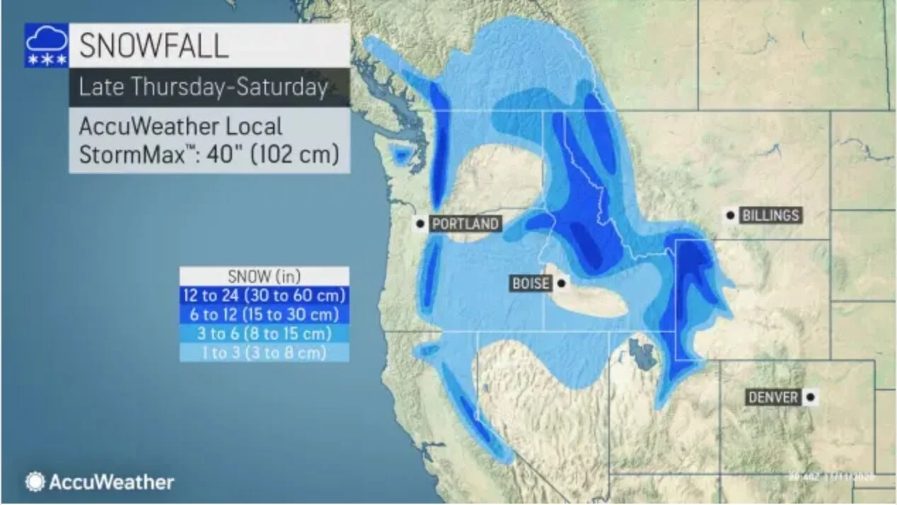
Rains are expected to begin on the coast on Thursday. Rain may turn to snow at higher elevations in the cascades and Eastern Oregon and Washington on Thursday.
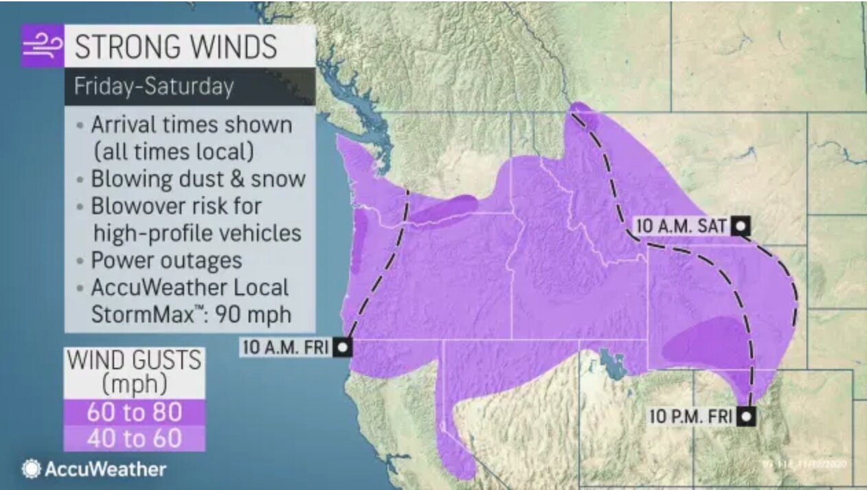
Friday morning the storm is expected to hit the coast and the gorge with high winds and heavy downpours of rain before moving further into Eastern Oregon and Eastern Washington. There will be gusts in the gorge in the gorge and high winds on the coast. With snow predicted to fall in higher elevations. Low elevation areas such as the Columbia River Gorge are less likely to see snow.
Drivers be advised that driving visibility will be low due to wind driven rains and snow. Snow tires are recommended for those traveling at higher elevations.
Some areas may be at risk for power outages due to high winds.
"It will be a beast of a storm," AccuWeather Senior Meteorologist Alex Sosnowski said, adding that it could end up being one of the most intense of the entire season
The US National Weather Service has announced that a winter storm warning is in effect from 4:00 PM PST until Friday, 6:00 PM PST.

Source. Weather Prediction for Thursday Afternoon-Night

Source. Pictured: Severe Weather Map from AccuWeather. A Winter Storm Warning is in effect for the dark blue areas on the map.

Source. Pictured: Severe Weather Map from AccuWeather. A Winter Storm Warning is in effect for the dark blue areas on the map.